Central Government
Co-investment in
River Management for
Flood Protection
Critical Adaptation to Climate Change for a
More Resilient New Zealand
August 2019

CENTRAL GOVERNMENT CO-INVESTMENT IN RIVER MANAGEMENT FOR FLOOD PROTECTION
PAGE I 2
Author(s): John Hutchings (HenleyHutchings), Julian Williams (BERL), Laws Lawson (Lawz Consulting) in
association with regional authority river managers and Taranaki Regional Council CEO Basil
Chamberlain.
Front cover photo: Anzac Parade, Whanganui, Whanganui River in flood, 2015

AUGUST 2019
PAGE I 3
Contents
Executive summary ............................................................................................................................................... 4
Purpose .................................................................................................................................................................. 6
Scope ...................................................................................................................................................................... 6
The challenge shared by regional authorities and central government ........................................................ 7
A brief history of river management for flood protection ............................................................................ 10
Current central government role ..................................................................................................................... 11
Assets protected ................................................................................................................................................. 11
Asset value and budgeted expenditure .......................................................................................................... 13
Flood risk management – shared investments and shared outcomes ....................................................... 13
Methods for moving forward ........................................................................................................................... 18
Request to central government........................................................................................................................ 20
Conclusion ........................................................................................................................................................... 22
Appendix 1: Case Studies .................................................................................................................................. 23
Appendix 2: from Tonkin + Taylor report ‘Hiding in Plain Sight’ (April 2018).............................................. 38
Appendix 3: Additional information to support comments made elsewhere in this paper .................... 52
References .......................................................................................................................................................... 58
This report was first released as a draft in November 2018.

CENTRAL GOVERNMENT CO-INVESTMENT IN RIVER MANAGEMENT FOR FLOOD PROTECTION
PAGE I 4
Executive summary
The purpose of this paper is to provide a case to support central government co-investing, alongside
regional communities and directly benefiting property owners, in river management and flood protection
schemes.
Improving flood protection is a critical, practical and achievable first action in adapting to climate change
to achieve a more resilient New Zealand, for the benefit of every New Zealander.
Flooding is the most common natural hazard we all face in New Zealand. In most cases New Zealanders
have been protected from the full force of flood events by river management and flood protection schemes.
These provide safety and security to around 1.5 million hectares of our most productive and intensely used
land and to over 100 towns and cities. They also protect the families and communities living alongside our
rivers. In total, these schemes currently provide an estimated annual benefit of over $11 billion each year.
This is over five times their capital replacement value.
The total estimated capital replacement value of the 364-river management and flood protection schemes
throughout New Zealand is $2.3 billion. Communities annually spend close to $200m maintaining these
schemes.
Regional authority research indicates the current structures have generally been well maintained in their
current configuration, and they have provided good value for money. However, the intensity and frequency
of climate change-induced weather events are increasingly placing stress on the integrity and risk reduction
capability of these schemes. This in turn significantly increases the risks faced by our communities and our
economy. This is of major concern to regional authorities and is likely an equal concern for central
government.
Present regional authority long-term provision for capital and operating expenditure primarily addresses
risks in a traditional way, albeit with some variation across New Zealand. Change is required. There is a
critical need to make more provision for climate change impacts and to plant more trees. There is also a
need to better protect land and assets, now valued more highly than when schemes were initially
constructed. In addition, ecological / environmental / whole catchment and iwi considerations need to be
incorporated into flood scheme solutions, in a more sympathetic and systematic manner than in the past.
The outcome sought is ‘fit-for-the-future’, risk-aligned and environmentally sensitive scheme infrastructure
providing appropriate levels of resilience and safety to the communities and assets they protect.
Regional authorities estimate the annual capital cost of meeting these refreshed multiple objectives,
particularly the need to provide the necessary level of future resilience, would be at least $150m beyond
current $200m levels of capital and operating expenditure. In total, the estimated need for future
investment in flood risk mitigation therefore totals more than $350m per annum for at least the next ten
years.
In the past, (prior to the early 1990s), the capital cost of substantial river management and flood protection
schemes was commonly supported at levels of 50% to 75% by central government with maintenance and
operating costs at rates of around 33%. A review of documents from the time suggests this national support
typically amounted to over $114m per annum in today’s dollars.
In the three decades since the central government stopped funding flood protection works, the Crown’s
assets have received flood protection at a cost to regional and targeted local ratepayers, with no
contribution from the Crown
1
. These protected assets include rail and road infrastructure, some airports,
education facilities, Crown land and health facilities and more broadly, the efficient functioning of the
economy and communities.
1
The Crown does not pay rates on its assets.

AUGUST 2019
PAGE I 5
Present funding arrangements are neither equitable nor sustainable for addressing present and emerging
needs. The essential request to central government is for it to ‘return to the table’ and financially share in
the task of providing necessary fit-for-the-future protection against New Zealand’s primary natural hazard
risk - flooding.
The national interest in doing this is clear. It is to protect public safety, provide community resilience,
mitigate risks to the national economy, and protect nationally significant and publicly owned infrastructure
in a manner that addresses the increased risk from climate change.
The challenges are real, substantial and present now.
These challenges are also becoming more complex and
difficult as time passes. A committed central
government / regional authority co-investment
response is required so that necessary changes can be
implemented in an orderly, timely, community-focused
and adaptive manner.
An added advantage of such a change in approach is it
will reflect a necessary shift in central government focus
from disaster relief and rehabilitation towards a fence
at the ‘top-of-the-cliff’ mitigation of the risks faced by
communities, regions and the nation.
In the absence of central government co-investment in mitigating risks, scheme re-design and re-
construction will not be able to deliver expected nationally defined resilience-focused outcomes. This will
inevitably mean more central government funds having to be directed towards ‘ambulance at the bottom
of the cliff’ recovery and rehabilitation.
National annual funding, in the order of at least $150 million, with a three-year ramp-up, is recommended.
To achieve this level of co-investment, a long-term funding formula is proposed with:
• Co-investment of up to 75% assistance contributed by central government toward the cost of new works
involving fully integrated catchment schemes, to recognise the importance of adopting a climate change
adaption approach, alongside achieving a wide range of other objectives – including planting more trees to
better manage sediment run-off and improve water quality and possibly assistance with ‘managed retreat’.
• Co-investment of up to 50% assistance contributed by central government toward the cost of the capital
works required to upgrade existing river management and flood protection works to enable them to be
better adapted to cope with climate change-induced storm events and to begin to achieve a wider range of
other current and future objectives.
• Co-investment of 33% of assistance from central government toward the maintenance of existing
scheme works in recognition of the role they play in protecting Crown assets / related infrastructure and
to enhance the role they play in sustaining the operation of national and regional economies and
communities.
The actual co-investment share at any single location will vary and should reflect a range of considerations,
perhaps in a similar manner to the financial assistance rate (FAR) applied to central / local co-investment in
transport solutions.
Details about the preferred design of a co-investment model should be prepared by a central and local
government officials group, supported as needed by external advice and led by Treasury. This group should
be invited to provide recommendations to ‘Resilience Group’ ministers and regional authority chairs within
three months of the receipt of this paper, including making decisions about immediate investment
priorities. Provision for central government co-investment in river management for future flood protection
should be included in Budget 2020.
The need is for river management and
flood protection schemes to be re-
purposed and upgraded, or renewed,
to meet contemporary challenges,
including adaption to cope with
climate change-induced flood events.
The schemes must also satisfy a wider
spectrum of community,
environmental, cultural and economic
objectives than in the past.
CENTRAL GOVERNMENT CO-INVESTMENT IN RIVER MANAGEMENT FOR FLOOD PROTECTION
PAGE I 6
Central Government Co-investment in River
Management for Flood Protection
Purpose
The purpose of this paper is to provide a case to support future central government co-investment,
alongside regional authorities
2
and directly benefiting property owners, in river management and flood
protection schemes.
The paper is supported by three appendices with case study examples, additional evidence, and further
descriptive material, to support the logic for river management for flood protection co-investment by
central government
3
.
Scope
This paper focuses on natural water flowing in rivers and streams, from the catchment watersheds to
the sea. The paper does not include consideration of storm water systems and the networks of water
related infrastructure - often referred to as ‘the three waters’.
4
Rivers generally flow in a natural pattern across our landscape, although sometimes their flows are
boosted by drainage works and sometimes their flows are constrained and channelled via river
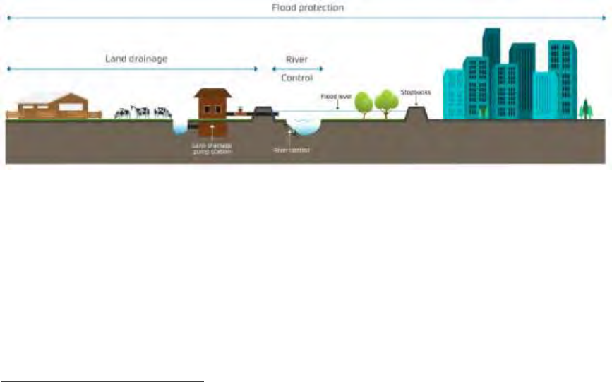
management and flood protection schemes (Figure one). It is these drainage works and river
management and flood protection schemes that are the core subject of this paper.
Figure one: Schematic of river management, flood protection, land drainage services (Source: Tonkin and
Taylor, March 2018)
The paper does not include consideration of works to mitigate against coastal erosion or the effect of
land inundation from waves breaking over a foredune and flooding the immediate coastal lowlands
behind the sand-dunes. However, the paper does include consideration of the measures sometimes
required in estuary areas, where river water is held up by a storm surge until it can naturally drain to
the sea.
The central government co-investment proposal, at the heart of this paper, could possibly be influenced
by consideration of future local government funding options or other Government policy reviews, but
2
Regional authorities include the regional councils and the unitary district councils (the latter carrying out the functions of
both a district council and a regional council). There are 16 regional authorities throughout New Zealand.
3
These appendices include critical parts of a paper prepared for regional authorities by Tonkin & Taylor Ltd titled ‘Hiding
in Plain Sight’ (April 2018).
4
The ‘three waters’ project addresses water/wastewater and storm-water transported in reticulation systems such as
sewers, pipes and street gutters. Management of flood waters is not and never will be part of the three waters project.
River control and flood management provide significantly different contributions to national outcomes than the other
services local government provides. It requires a whole catchment approach. It is also reliant on a mandate established in
specific and discrete legislation, rather than the generic Local Government Act 2002, and it is delivered as a function, duty
and responsibility of regional authorities rather than territorial local authorities.

AUGUST 2019
PAGE I 7
there is a need for flood-risk mitigation matters to be progressed with priority and not be held up by
the likely complexity of generic local government funding and related issues associated with territorial
local authority functions. This includes issues such as managed retreat and insurance which, while
related, are being dealt with in other forums.
The challenge shared by regional authorities and central
government
As a group of small islands in the ‘roaring forties’ weather system, New Zealand regularly experiences
high-intensity rainfall. On average, a major damage and loss causing flood occurs every eight months.
Floods are New Zealand’s most frequent and, cumulatively, most significant and most avoidable
hazard.
5
Flood hazards are most often avoided because of the efficacy of river management, drainage and flood
protection schemes. Regional authority research indicates the current structures have generally been
well maintained in their current configuration and have provided good value for money (Figure two).
They have been managed in a prudent, professional and efficient manner. However, significant
adjustments are now required to meet the challenges of today and the future.
Climate change adaptation
The intensity and frequency of climate change-induced weather events is substantially increasing the
severity and frequency of the risk of flooding.
6
This is causing higher levels of damage to the assets
located behind existing structures and to adjacent communities, cities and towns, with associated social
and environmental costs. We have seen regular recent reminders of this
7
. Climate change will also shift
the geographical risk areas for floods and make new areas more susceptible to floods.
The severity of the consequences of not securing and enhancing the integrity and service levels of
existing structures, and the community resilience role they play, increases every day.
8
The increased
frequency and severity of flood occurrence is influenced by several climate change-induced ‘additive
factors’ including:
• More intense rainstorms generating higher river flows.
• Those flows causing more soil erosion.
• Higher sea levels and more significant storm surges, over-time, affecting the control conditions
and significantly increasing flood heights for several kilometres up many river systems.
9
5
Over the past 100 years, New Zealand has experienced over 1,000 serious floods making flooding, due to intense or
prolonged rain, the most frequent natural hazard New Zealand faces (Ministry for the Environment, 2008).
6
Generally scheme designs, looking to allow for climate change out to 2100, would use an increase in peak flood flows of
approximately 20%. This is based on the latest NIWA report prepared for MfE (HIRDs V4). That report states for every
degree of temperature increase there is a corresponding 10.1% increase in rainfall (this is called the augmentation factor).
Using the RCP6 climate change scenario out to 2100 (the mid-range CO2 emission scenario) this gives a 2.0-degree
temperature increase or an equivalent increase in rainfall intensity of 20%. A 20% increase in rainfall will generally
translate into a 20% increase in peak flood flows. These higher flows will also give rise to increased flood heights because
of higher sea levels and greater sediment flows.
7
The first appendix to this paper provides relevant case studies.
8
Lawrence et al (2013) suggest that what is considered a 40-year return period event now, will be reduced to the
equivalent of an 8-year return period event by 2090. The findings recorded by Lawrence are reinforced within
publications from GNS Science.
9
This includes large areas of drained land on the Hauraki Plains of the Waikato region and land adjacent to Edgecumbe,
which in some places is now below sea level. It also includes the protection of cities like Lower Hutt and Christchurch i.e.
schemes protect far more than the intensive farming and horticultural activity often established on lowland areas. In fact,
schemes provide protection to all types of economic and human endeavour at almost all New Zealand locations.
CENTRAL GOVERNMENT CO-INVESTMENT IN RIVER MANAGEMENT FOR FLOOD PROTECTION
PAGE I 8
• In combination, the above elements leading to more deposition of rocks, stone, gravel and silt
in mid to lower river reaches with resultant significantly increased flood heights.
Other requirements and opportunities
As a nation, we need to define an ‘acceptable level’ of ‘climate change-induced’ risk and then establish
schemes to manage floods to achieve that level of risk. On top of this, flood management activities must
now also be multi-purposed and consequently, implemented in a way that:
• Better achieves integrated land use.
• Enhances ecological values.
• Improves water quality outcomes.
• Better reflects iwi and community aspirations about the management of natural systems.
We need to invest to be more ‘fit for the future.’ This approach necessarily makes flood protection
assets core ‘economic enabling’ infrastructure for a resilient New Zealand.
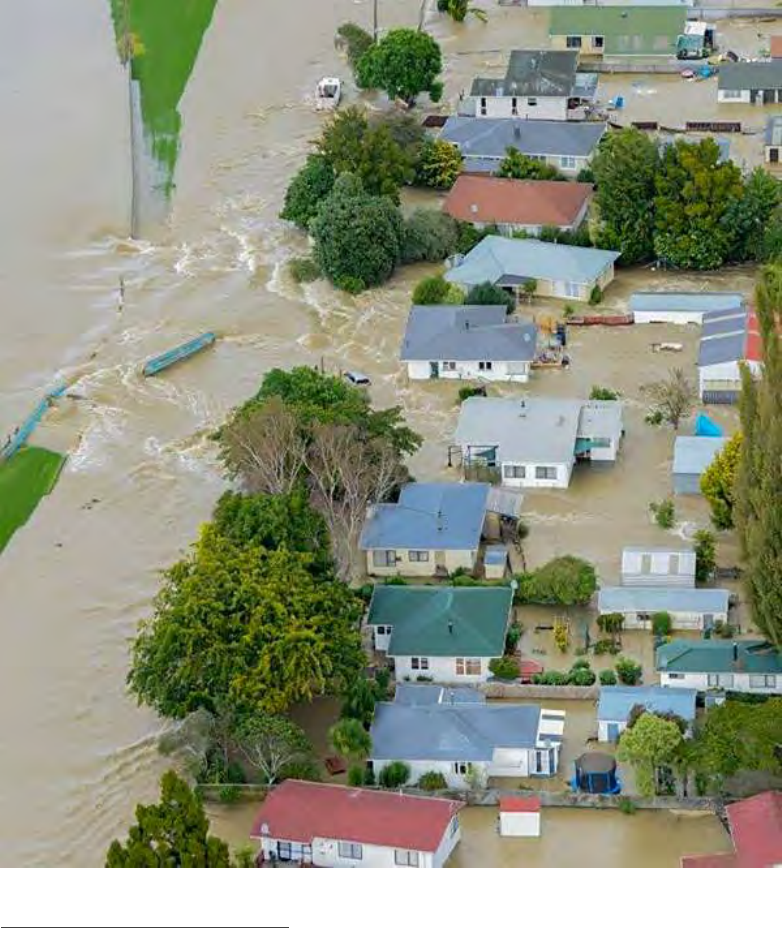
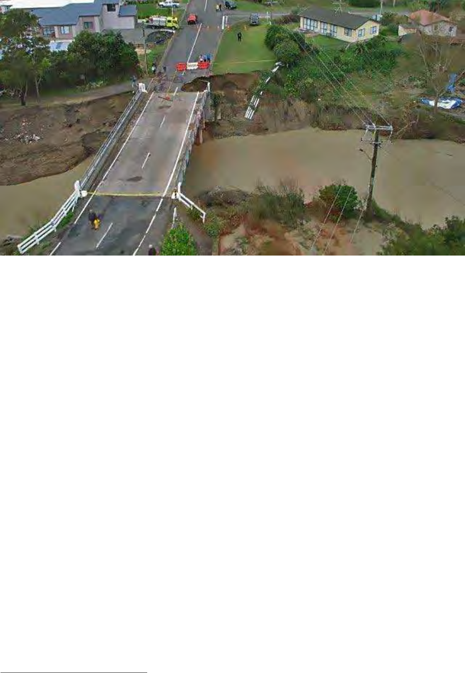
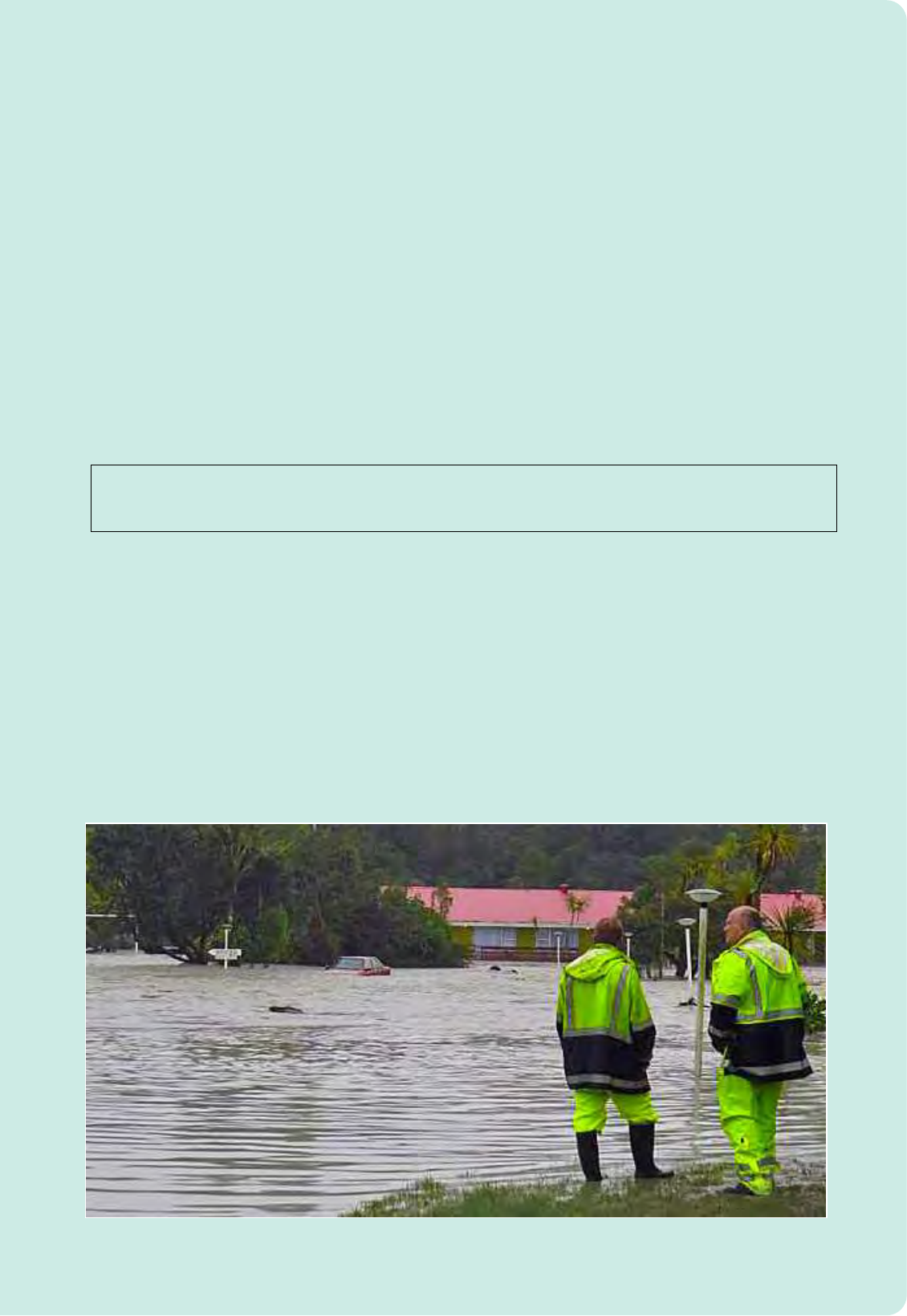
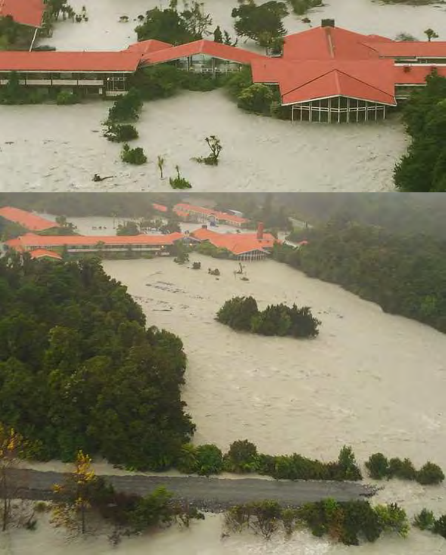
Extensive inundation of Edgecumbe following the failure of Rangitāiki River stop-banks in April 2017.
AUGUST 2019
PAGE I 9
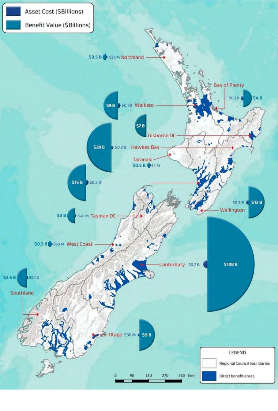
Figure two: Net Present Value of scheme benefits
10
and operational costs by region (Source: Tonkin & Taylor,
April 2018)
10
The net present benefit / value of all schemes is $198b in 2016 dollars. (NB ‘net present benefit’ is the sum of benefits in all future years
expressed in 2016 dollars).
Manawatū-Whanganui

CENTRAL GOVERNMENT CO-INVESTMENT IN RIVER MANAGEMENT FOR FLOOD PROTECTION
PAGE I 10
Regional Authorities’ River Managers Special Interest Group
Regional authorities have the capacity to get the job done if the money is available to meet necessary
‘agreed risk profile’ programmes. A planned, carefully prioritised and inter-regional response approach is
proposed – noting that in some locations the solution may be more complex than in other locations.
As part of this planned approach, the regional authorities’ River Managers’ Special Interest Group has
developed a comprehensive ‘Five Year Sector Resilience, Sustainability and Improvement Plan’ for flood
protection, river management and drainage. As part of this Plan, a work programme has started that covers
four key areas requiring renewed focus on:
• Working together across the sector, including seeking co-investment with central government.
• Applying consistent practices, methodologies and standards.
• Recruiting quality people.
• Communicating and creating an enabling environment.
The challenge
The essential challenge is this: the cost of construction and maintenance of schemes to meet future
‘acceptable levels of risk’ is beyond the reasonable capacity of ratepayers and directly affected property
owners alone, to provide. Exacerbating this situation is a concern these parties are increasingly bearing a
disproportionate share of scheme costs when compared to those, such as the Crown, who benefit from
such schemes. In addition, regional communities face significant constraints on their ability-to-pay to
achieve the multi-objective demands now required to be served by their ‘river management for flood
protection’ schemes. Central government needs to come to the party.
A brief history of river management for flood protection
New Zealand previously led the world with its recognition in 1941 that land and water management for
flood protection needed to be catchment based. The purpose of the Soil Conservation and Rivers Control
Act 1941 is … ‘to make provision for the conservation of soil resources and the prevention of damage by erosion,
and to make better provision with respect to the protection of property from damage by floods’. This statute led
to joint investment by central government, regional communities and directly benefiting property owners,
in river management, drainage and flood protection schemes.
Most river management, drainage and flood management schemes were constructed up to half a century
ago. The value of the assets protected by these schemes has incrementally increased and is now very large.
The type of land use activity carried out on this protected land is more intense than that initially envisaged
at scheme design and construction and the scale of adjacent urban development has also intensified. A
fresh perspective on the important role played by schemes is now required.
Prior to the early-1990s, the capital cost of river management and flood protection schemes was commonly
supported by central government at rates of 50 to 75%
11
. Maintenance, to ensure the integrity of the
performance of these schemes typically received 33% support from central government. Collectively, this
level of support amounted to around $40m per annum from central government. That is equivalent to over
$114m per annum in today’s dollars.
Since the early to mid-1990s, river management and flood protection schemes’ funding has relied
almost entirely on regional and directly benefiting property owners via targeted rates. By comparison,
internationally, including in Europe and the UK
12
, most developed countries currently have significant
11
We note the Waihou Catchment control scheme – a very large whole catchment scheme (and the largest addressed in a
holistic manner in the country), received a 87.5% government grant.
12
In the United Kingdom the current Environment Agency programme, which runs from 2015-16 to 2020-21, includes 1,136
flood and coastal erosion projects at a projected total cost of just over £6bn.

AUGUST 2019
PAGE I 11
levels of central funding for flood protection activities, in recognition of the national benefits they
provide
13
.
We acknowledge that managed retreat must be given more active consideration now than in the past.
Regional authorities will need to work closely with central government and district / city councils on this
challenge but, no matter what is achieved through retreat, improvements to existing river management
schemes are urgently required now to better manage existing risks.
In comparison to the challenge of managing the effects of gradual sea level changes (but please
recognise we are not wanting to diminish the need for sea-level-rise response action in any way),
extreme flood events are happening now, there are well developed response capabilities already in
place and there is a very clear understanding of the practical actions that can be taken, with real
adaptation effect. The need for this capability was clearly demonstrated by the April 2017 storm event
that was off the charts in terms of its return period frequency, causing catastrophic failure of stop bank
protection on the Rangitāiki River at Edgecumbe.
Current central government role
Central government’s current role is more as the ambulance at the bottom of the cliff than as a health
/ wealth assister and advisor at the top of the cliff. Government’s role is currently focused on disaster
response, relief and rehabilitation. Funding arrangements are generally applied after the event.
Anticipatory central government funding to reduce risk and prevent future losses is minimal.
14
More particularly, central government currently has two roles. Firstly, it has an enabling role - to ensure
regional authorities have the power to manage hazards, including flooding. Key legislation includes the
Local Government Act 2002, Resource Management Act 1991, Soil Conservation and Rivers Control Act
1941, Land Drainage Act 1908 and the Civil Defence and Emergency Management Act 2002.
Secondly, when an event occurs of a size beyond local government’s ability to cope, central government
assists with response measures and provides financial assistance to speed up recovery. This assistance
is per the National Civil Defence Emergency Management Plan 2006. If a major flood damages critical
flood defence infrastructure, then central government will also meet up to 60 percent of the asset’s
repair cost, once damages reach a certain threshold, although we understand this level of assistance is
now under review.
15
Assets protected
River management and flood protection schemes provide outstanding value to the New Zealand
economy
16
. Over 100 towns and cities across the country have families and communities living alongside
rivers or on flood plains that are protected. In total, river and flood protection structures protect around
1.5 million hectares of land or 5% of New Zealand’s land area.
This land is where a very high proportion of our economic enterprise takes place. It includes areas of
highly productive primary sector enterprise of significant value to the New Zealand economy.
13
We acknowledge that the central / provincial government responsibilities in Europe are different from those applied in
New Zealand. The principle emphasised here is that European countries tend to give higher recognition to the national
benefits of river management for flood protection than in New Zealand.
14
For example, central government may provide funding for research through the science system to provide some
limited guidance to the role played by regional authorities, but little else. In rare circumstances such as for the Waiho
River at Franz Josef, NZTA has entered into arrangements with regional authorities to contribute towards the cost of river
management works to protect state highways.
15
Government may also provide aid to parties affected by flood events, within the terms and conditions defined in the
‘On-Farm Adverse Event Recovery Policy’ administered by the Ministry for Primary Industries.
16
See the information included as part of the extract from Tonkin & Taylor in the appendix. See also Figure one included
earlier in the current paper.

CENTRAL GOVERNMENT CO-INVESTMENT IN RIVER MANAGEMENT FOR FLOOD PROTECTION
PAGE I 12
Schemes are designed and constructed to achieve defined performance levels, based on expected land
use. Where a flood event exceeds the design capacity, there will be resultant flooding and damage. The
2004 Manawatū floods provide an illustration of the extent of the types of costs incurred because of
this damage. Insured losses from that event were $112 million. However, the cost to the agricultural
sector alone in uninsured losses (lost production and uninsurable rehabilitation costs) were calculated
at $185 million.
17
The Tonkin & Taylor report ‘Hiding in Plain Sight’ (March 2018)
18
suggested the schemes provide an
estimated Net Present Benefit of over $11 billion each year. This benefit value has increased markedly
since the schemes were constructed, because of the advent of a full range of more intensive land uses
and associated property values.
It is somewhat ironic that while flood protection schemes have been extremely good investments, the
analysis also implies that under-investment has probably occurred since their construction. With the
value of protected property ramping up in recent decades, there should generally have been a
commensurate ramping up of protection service levels, to achieve significantly higher levels than
original design. This has only occurred variably.
Adding complexity are the effect of climate change impacts on protection levels. These climate change
impacts are effectively reducing protection service levels at many locations, particularly where scheme
improvements have not been progressed.
19
More people are now being exposed to risks to their safety
than ever before.
Protection of Crown assets
One of the effects of central government being narrowed to the roles described earlier is that, for three
decades, Crown owners and other infrastructure asset owners, have received asset protection at a cost
to regional and targeted local ratepayers. These protected assets include rail and road infrastructure,
lifeline infrastructure such as power lines and water supply and sewage networks, some airports,
20
communication services, schools, hospitals, universities and public conservation land.
Estimates by Ericksen (1986) cited by the NZIER (2004) show that for floods in Nelson and New Plymouth
in 1970 and 1971, losses associated with central government works and services (roading, railways, bulk
power supply, flood control and drainage works) amounted to 49 per cent of the total value of all direct
losses. An example is provided by the Leith Flood Protection Scheme in Dunedin. This Scheme plays a
significant role in protecting the CBD from flooding. This includes the protection of education facilities
(University of Otago and Otago Polytech) and the sites for the new Dunedin hospital, public reserves,
residential and commercial areas. The capital value of Crown properties and non-relatable University
land and assets, in the area protected by the Scheme, is 35 per cent of the total assets in the area. The
17
The cost of emergency services and infrastructure repairs during the 2004 Manawatū floods was put at a further $90
million. The flood was modelled as having a 150-year return period.
18
The reason underpinning the use of this ‘Hiding in Plain Sight’ title is relevant to the issue being addressed in this paper.
The protection provided by engineered infrastructure, located at the heart of river management and flood protection
schemes, is not usually visually intrusive and is not often apparent as they ‘do their job,’ perhaps only once or less a year.
Consequently, the protection provided by such schemes is very much taken for granted by New Zealanders, despite the
increasing risks currently faced.
19
Schemes are facing a ‘pincer’ challenge, where simply maintaining current assets is seeing the benefit of these
maintenance gains eroded by the effect of climate change-induced flood events. Ideally, service levels should be
substantially increasing to protect the more valuable public and private assets located behind this protection
infrastructure and to better cope with climate change induced higher magnitude / frequency events.
20
Airports such as those at Christchurch are located on flood plains. Many New Zealand airports are 50% owned by the
Crown.

AUGUST 2019
PAGE I 13
benefit received from flood protection is equivalent to the level of economic impact avoided. Six months
after the 2006 Leith flooding event, the total economic impact on Dunedin was $154m.
21
Asset value and budgeted expenditure
The total replacement value of the 364 river management and flood protection schemes throughout
New Zealand is estimated at $2.3 billion.
22
Regional authority Long Term Plans for 2018 to 2028 show budgets for operating expenditure of at least
$1 billion and, in addition, capital expenditure of a further $1 billion for this ten-year period is allowed
for. This excludes depreciation.
These budgets are, to varying degrees, based on a continuance of the same design paradigms as were
applied when the schemes were initially constructed. They do not reflect the quantum and systemic
change needed to recognise emergent contemporary challenges, particularly the incremental impacts
of climate change.
Regional authorities are concerned they are on the cusp of a significant ‘infrastructure deficit’ problem
that will just get worse unless acted upon. There is a massive renewal programme ahead of them, not
simply a maintenance programme, nor simply a matter of replacing existing infrastructure with ‘like for
like’.
The schemes operate in a living environment. They are subject to wear-and-tear and now must endure
increased loading from the changing nature of weather events and the increasing value of the assets
they protect and the public safety benefits they provide.
The upshot is that additional investment is urgently needed to enable the schemes to be fit-for-
purpose for the next generation. There is not enough ‘ability-to- pay’ in the regions to meet the cost of the
changes now needed to provide appropriate flood risk mitigation, in a manner that is equitable and
achieves broader national outcomes.
Flood risk management – shared investments and shared
outcomes
Regional authorities have hard choices to make. Existing schemes and new areas of land need significant
investment to sustain even their current levels of river management for flood protection service, let
alone to meet future challenges. Any capital investment should be equitably shared. Funding to do this
should come from all of those who directly or indirectly benefit.
To avoid a worst-case flood disruption scenario, scaled-up central government and regional authority
investment in risk reduction measures will be required.
The priority objective is to create resilient communities and places where future generations can safely
live and undertake economic enterprise. Companion objectives include:
• Support for well-functioning ecosystems.
• Improved water quality.
21
Source: ‘Benefits of the Leith Lindsay Flood Protection Scheme to Crown Properties’, prepared for Otago Regional
Council by Market Economics, April 2011
22
Source: Tonkin & Taylor report ‘Hiding in Plain Sight’ (April 2018).
CENTRAL GOVERNMENT CO-INVESTMENT IN RIVER MANAGEMENT FOR FLOOD PROTECTION
PAGE I 14
• Satisfaction of the expectation of our communities and iwi partners that our rivers will be
managed as national treasures.
Higher levels of resilience against the risks of extreme floods will also contribute to the full suite of
government objectives, including investment certainty and social cohesion. These benefits will be
expressed in all regions, not just the ‘richer’ regions.
The cost of flood hazard events may be counted not just in terms of the cost of replacing buildings,
other property losses and the real risk to life and social disruption. There are also other tangible costs
such as the number of hours or days businesses cannot operate at full production. In addition, flood
costs have both an immediate and sometimes an on-going effect on people’s lives. This includes the
effect on their willingness to want to continue to live and invest in areas subject to hazards.
Unfunded liability
The government’s 2015 ‘Thirty Year Infrastructure Plan’ noted average annual costs of responding to
flood events now exceed $50 million. While necessary, this may be viewed as sub-optimal expenditure
in that it occurs after the storm event. As such, it does not minimise future risk to the community or
central government. This ‘after event’ focus also means government bears an excessive unfunded future
liability in its fiscal accounts.
The severity of the consequences of not securing and enhancing the integrity and service levels of
existing structures, and the community resilience role they play, increases every day. The fiscal
consequences for government of not proactively investing at the top of the cliff are growing at a similar
rate. It is only a matter of time before lives are lost.
Consistency with election priorities
The current emphasis on remedy after the flood event, and therefore an implicit acceptance of often
irreversible asset destruction, is contrary to clearly stated coalition government election promises.
These include those related to:
• Lifting the productivity potential of the regions.
• Job creation.
• Social inclusion.
• Healthy and cohesive societies.
• Improvements to the well-being of all New Zealanders.
• Improvements to the environment we live in.
There is also an alignment between investment in river management for flood protection
responsibilities and government’s water quality, carbon sequestration and the ‘whole-of-catchment’
climate change adaptation programmes and policies, including the commitment to plant one billion
trees.
Provincial Growth Fund
Establishment of the Tuawhenua Provincial Growth Fund (PGF) was an early commitment by the
government to assist with regional development. The Cabinet Paper on this Fund notes:
• Nearly half of New Zealand’s population lives outside the main urban centres.
• Areas outside the main urban centres generate around 40 per cent of the country’s economic
output.
• If the provinces are not doing well, New Zealand’s overall economic performance will be
affected.

AUGUST 2019
PAGE I 15
• Diversification of the economy will make it more environmentally sustainable.
With the above points in mind, the government committed to invest $1billion dollars per year, for three
years, to support regional economic development. This was viewed as an essential component of its
economic strategy for the benefit of all New Zealanders.
The value of new investment in other regional infrastructure, including that such as rail, made with the
assistance of the PGF
23
, will be at risk if there isn’t commensurate investment in infrastructure
protection. Managing flood hazards is a critical element of this protection.
Treasury’s Living Standards Framework
Treasury’s Living Standards Framework and Budget 2019 has moved towards a ‘four capitals’ approach
inclusive of:
• Natural capital, with reference to all parts of the environment needed to support life and human
activity.
• Financial / physical capital, with a direct role in supporting incomes and material living
conditions.
• Human capital, with reference to the things which enable people to participate fully in work,
study, recreation and society.
• Social capital, with reference to the norms and values that underpin society.
All elements of the new Living Standards Framework imply the need for active central government
investment in the management of flood risks.
Resource Management Act 1991 and Treaty Settlements
The Resource Management Act (RMA) was amended in 2017 to provide for the inclusion of natural
hazards, as a matter of national importance. The Cabinet Paper to support this change indicates the
provisions will help ‘ensure that development does not occur in areas where the community deems risks from
natural hazards to be too high, unless the management of those risks has been adequately addressed’. This
implies recognition of a need for central government to more actively consider the role it plays in the
management of flood risks.
The RMA also places costly obligations on scheme owners and managers to meet environmental and
cultural obligations. In addition, numerous Treaty settlements impose obligations that have the effect
of adding new complexity and costs to the task of designing and managing river management and flood
protection schemes.
Australian Productivity Commission
The Australian Productivity Commission suggests, by implication, that the principles underpinning the
current New Zealand approach deserve re-examination. Its recommendation to the Australian
government is that the government adopt a formula for allocating mitigation funding to achieve
‘greatest net benefits, after considering the future risks of natural disasters’. With this point in mind, the
Commission called for the Australian government to increase annual mitigation funding contributions
to state and territory governments by $100 million in the first year, then to $150 million in the second
year and $200 million in the third year.
24
New Zealand should take a lead from this precedent setting
Australian recommendation.
23
This includes the significant investment made into KiwiRail assets as part of Budget 2019.
24
This recommended ‘federal’ commitment is on top of commitments already made at the state and local levels.

CENTRAL GOVERNMENT CO-INVESTMENT IN RIVER MANAGEMENT FOR FLOOD PROTECTION
PAGE I 16
The Sendai Protocol
The Sendai Risk Management Protocols of the United Nations (2015), to which New Zealand is a
signatory, recognise the importance of investing in risk mitigation activities. The National Resilience
Strategy being developed by the Ministry of Civil Defence and Emergency Management aligns with the
Sendai Protocols.
The Sendai Protocols reflect four priorities:
• Priority 1: Understanding disaster risk.
• Priority 2: Strengthening disaster risk governance to manage disaster risk.
• Priority 3: Investing in disaster risk reduction for resilience.
• Priority 4: Enhancing disaster preparedness for effective response and a commitment to “Build
Back Better” as part of recovery, rehabilitation and reconstruction.
These priorities clearly imply a need for central government to play an active role in risk mitigation.
Climate Change Bill
The Climate Change Response (Zero Carbon) Amendment Bill (2019), was introduced on 8 May 2019.
This amends the Climate Change Response Act (2002). The amended purpose of the proposed Act is to
provide a framework through which New Zealand can develop and implement clear and stable climate
change policies. The Bill is expected to come into effect in November or December 2019.
One of the purposes of the Bill is to require the government to have a plan for how it adapts to the
effects of climate change. A Climate Change Commission will be established to assist with this task.
Among other things, this Commission will conduct a national climate change risk assessment every six
years and, in response to each assessment, the responsible Minister will produce a national
adaptation plan
25
. River management for flood protection will inevitably be an important part of that
plan.
Productivity Commission – draft report on local government funding and financing
The Productivity Commission released its draft report from an enquiry into local government funding
and financing, in July 2019. River management was selected by the Productivity Commission as an
example of a function deserving of attention as a model for a stepped-up co-investment-focused
arrangement between central and local government.
The terms of reference for the enquiry, as issued by the Ministers of Finance and Local government,
noted that:
➢ Local authority debt has grown steadily since 2006 to the point where some councils are now
coming close to their covenanted debt limits.
➢ One of the major factors influencing local authority debt is the cost of adapting communities
and infrastructure to mitigate risks and hazards associated with climate change.
25
The well-respected editors from the weekly newsletter Trans-Tasman described (9 May 2019) the Bill as creating ‘a legal
obligation on the government to plan for how it will support New Zealand towns and cities, business, farmers and iwi to adapt to
increasingly severe storms, floods, fires and droughts we are experiencing as a result of climate change.’ Such planning could
rightly be expected to include co-investing in river management schemes to help protect against the effects of flooding.

AUGUST 2019
PAGE I 17
The Commission favours the “benefit principle” as the primary basis for deciding who should pay for
local government services. In this regard, the Commission further notes that ‘some local assets and
their associated services could benefit… national interests. In these cases, the benefit principle points to
shared funding with a contribution from central government
26
.
In addition, the Commission identified four key areas where the existing funding model is insufficient
to address cost pressures, and new tools are required:
➢ Supplying enough infrastructure to support rapid urban growth.
➢ Adapting to climate change.
➢ Coping with the growth of tourism.
➢ The accumulation of responsibilities placed on local government by central government.
All four of these identified areas support the need for co-investment by central government in river
management schemes. In addition, the Commission suggest the Government should extend the role
of the New Zealand Transport Agency (NZTA) in co-funding local roads, to include assistance to
councils facing significant threats to the viability of local roads and bridges from climate change.
Summary – reasons for central government co-investment
In summary, the reasons for a return to active central government co-investment in flood risk mitigation
are that it:
1. Is more fiscally responsible and fairer than focussing on post-event response and recovery.
2. Reflects Treasury’s new performance measurement and Living Standards Frameworks.
3. Is supportive of wellbeing and social inclusion and reflects equity / ability to pay considerations.
4. Is supportive of job creation and lifting the productive potential of the regions.
5. Contributes to the security of access routes (rail and road) for commerce.
6. Directly protects Crown assets.
7. Contributes to investment ‘opportunity costs.’
8. Contributes toward satisfying its moral and legal responsibility to support New Zealanders as
they attempt to adapt to climate change-induced extreme weather events.
9. Works against the risk of escalating insurance premiums or the risk of insurance companies
refusing to provide insurance cover in flood risk areas.
10. Contributes to the environmental and water quality expectations of our communities and iwi
partners.
11. Provides for resilience and adaptation against the effects of climate change-induced ‘above-
design’ storm events.
12. Above all else, provides resilience and increased levels of safety to existing and future
individuals and communities.
26
Page 4: Productivity Commission, Draft report, Local Government Funding and Financing, July 2019.
CENTRAL GOVERNMENT CO-INVESTMENT IN RIVER MANAGEMENT FOR FLOOD PROTECTION
PAGE I 18
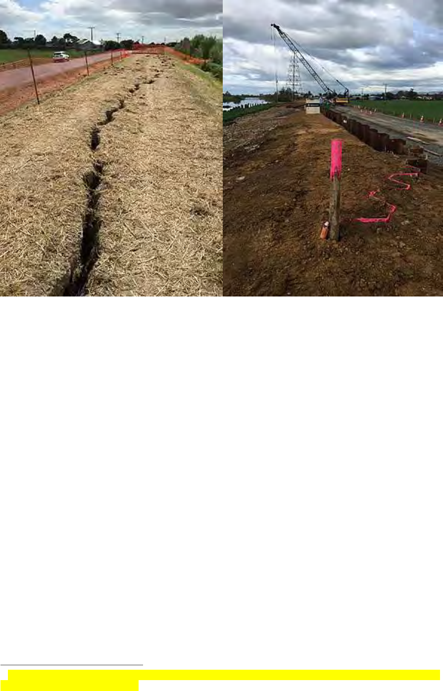
Waimarama Bridge North, Hawkes Bay Floods 2011
Methods for moving forward
The options for the future range from a ‘business as usual’ approach, to managing the retreat of some
land uses and communities from certain areas, to those solutions involving the construction of
enhanced infrastructure in association with whole-of-catchment solutions.
For all situations, options need consideration within the context of present-day flood risk realities. We
are facing circumstances of ‘real and present danger.’ And as is the case with many complex issues, it is
important that a full range of risk reduction methods are applied in tandem.
Business as usual (not recommended)
Maintaining existing scheme service levels
27
is not tenable, nor practical, because the influence of
climate change is such that current levels of resilience will continue to be eroded. This, in turn, will result
in:
• Increased risk to public and private local, regional and national assets.
• Increased demands on emergency and recovery funding.
• Increased insurance premiums.
• Increased risks to public safety and a risk to life.
• Increased numbers of communities unable to get insurance.
• Increased community and personal hardship and distress.
• Increasingly negative impacts on local, regional and national economies and the environment /
ecological and iwi values.
27
A ‘Service Level’ is calculated using one of three methods: a scope of physical works agreed with the affected
community; or a scope of physical works with a target capacity e.g. a maximum channel flow and; or a scope of physical
works with a level of performance defined in terms of a target return period e.g. a one in one-hundred-year event.
AUGUST 2019
PAGE I 19
Community / planned withdrawal (may be possible at some locations)
This option proposes to reduce risk by reducing activity in flood risk prone areas. But asking residents
and businesses to withdraw from locations at risk of being flooded, particularly when this relocation
involves urban communities, is extremely difficult. The sunk costs of existing investments are very large
and the impact on landowners of allowing rivers to flow more freely will extend both upstream and
downstream of the ‘run free’ location.
The social and political disruption associated with this option is likely to make it unpalatable in many
cases. Nevertheless, there will be some locations within catchment schemes where this solution must
be considered an acceptable part of a more holistic approach.
Whole of catchment (favoured)
The desires of iwi and broader regional and national communities are that regional authorities apply
river management in a more environmentally benign / ecologically sensitive manner than in the past.
Integrated and sustainable land management or ‘whole-of-catchment’ approaches have always been a
core part of regional authority business. More substantial investment in whole-of-catchment solutions
will be required in the future. This option can reduce the level of sedimentation and erosion occurring
within our catchments. It will also improve the water quality in our rivers, estuaries and coastal waters
and contribute to biodiversity values.
To successfully adopt and achieve a ‘whole-of-catchment’ approach requires extensive ‘outreach work’
beyond that needed for a regional authority to design, gain agreement and construct improved flood
control schemes. For example, among other things, it requires one-on-one work with landowners to
alter land use practices and internal property infrastructure and change enterprises to achieve more
benign long-term water and soil and environmental outcomes.
Part of this work will involve planting trees. The one billion trees programme will be an important
contributor to these ‘whole-of-catchment’ solutions approach because, alongside other current
initiatives, it will:
• Accelerate application of sustainable land use practices.
• Promote the conversion of some areas from pastural uses into indigenous forest.
• Promote more extensive riparian planting.
• Accelerate careful consideration of the use of some areas for Mānuka planting and honey
production.
• Promote expanded plantation forestry in suitable locations.
• Help to forestall the risk of transferring this generation’s ‘challenges’ into compounded
problems for the next generation.
Enhanced infrastructure in association with whole-of-catchment solutions (preferred)
Sustainable land use is an essential ingredient of flood risk management. Investment in sustainable land
use also needs to be increased but, no matter how successful, it cannot and will not on its own, provide
the necessary level of protection to productive land and communities at levels desired by communities.
This is because ‘more sustainable land uses’ will have only a minor effect on the increasing amount of
rainfall from the inevitable and more intense, climate change-induced storms that will then need to be
transported by our rivers and streams. Enhanced river management for flood protection infrastructure
must be built into the solution, together with the occasional use of ‘planned withdrawal’.

CENTRAL GOVERNMENT CO-INVESTMENT IN RIVER MANAGEMENT FOR FLOOD PROTECTION
PAGE I 20
Request to central government
Regional authorities seek a central government commitment to co-invest, with regional authorities and
other directly benefiting property owners, in improving the integrity and resilience of flood risk
mitigation infrastructure. This should be alongside the wide-spread and comprehensive adoption of
whole-of-catchment solutions.
28
Collectively, such an approach will better achieve integrated land use, enhanced ecological values,
improved water quantity and quality outcomes and generally a better reflection of iwi and wider
community aspirations about how natural systems should be managed.
Regional communities and directly benefiting private property owners cannot fund the necessary step-
change needed to manage increased flood risks, in the more sophisticated manner set out above, on
their own. Central government and regional authorities must therefore share the task of addressing this
challenge. This is not about attributing blame for the failure of the efficacy of current systems. All New
Zealanders are facing the challenges of climate change. A new co-investment and funding partnership
approach with central government is sought
29
as the preferred path forward.
Regional authority river engineers have engaged in an active ‘foresight’ process to estimate spending of
$374m / year is required to ensure river management and flood protection schemes are ‘fit for the
future’. Regional authority Long-Term Plans (2018-2028) currently indicate operational and capital
expenditure of approximately $200m / year. The shortfall required to make the necessary step-change
to add resilience to the schemes, and to enable them to meet other contemporary objectives, is
estimated at $174m / year.
Central government co-investment of $150m per annum, with an incremental ramp-up to this level over
the first three years, and expenditure at this level for ten years, is viewed as a pragmatic contribution to
this necessary expenditure.
30
The balance of the shortfall in funding, currently estimated at $24m per
annum to meet the desired ‘future-proof’ status of these schemes, may be contributed through
increased regional rates and increased rates on directly affected private properties.
The actual co-investment share at any single location would reflect a range of considerations, perhaps
in a similar manner to the financial assistance rate (FAR) applied by NZTA to central / local co-investment
in transport solutions.
It was initially proposed that the Provincial Growth Fund (PGF) provide a short-term central government
funding solution to support four critically necessary scheme upgrade proposals
31
. Since preparing the
draft of this report (November 2018), government informed regional authorities they did not see co-
investment in river management schemes from the PGF being an appropriate use of those funds. Within
an overall national policy context, their preference was for it to be addressed as part of the ‘resilience’
work currently being progressed for consideration later this year by a group of ‘Resilience Ministers.’
28
The co-investment propositions outlined in this paper do not include provision for soil conservation planting and or
steep land retirement. These provisions are currently being separately considered by MPI. Budgets for these
complimentary activities could be sensibly combined with the proposed programme outlined in this paper under the later
described ‘new works involving fully-integrated catchment schemes category.
29
Regional authorities acknowledge that, alongside a government decision to co-invest in river management and flood
protection schemes, there is a need to establish related funding-accountability measures.
30
These estimates were derived by asking the river managers from the seven major river managing regional authorities
to make their own estimates, based on their knowledge of council policy and their various schemes, of the likely future
cost to make them ‘fit for the future’. These estimates were then moderated and applied across all 16 regional authorities.
Based on this moderation work, an average increase of 85% of the current spend of $200m is required, bringing the total
future expenditure need to $374m per annum for the next ten years.
31
These applications were for the: Lower Whanganui River in the Horizons / Manawatū-Whanganui Region; Awanui River,
Kaitāia in the Northland Region; Rangitāiki River, Edgecumbe in the Bay of Plenty Region and the; Waipaoa River, Poverty
Bay in the Gisborne region.

AUGUST 2019
PAGE I 21
This being the case, a long-term embedded and budget-based solution is the essential means for
providing for a planned and systematic programme for the provision of ‘fit for purpose’ flood protection
infrastructure. This may include consideration of the redirection of existing ‘response’ funding toward
mitigation investments.
Possible funding formula / levels of co-investment
A long-term funding formula is proposed with:
• Co-investment of up to 75% assistance contributed by central government toward the cost of
new works involving fully-integrated-catchment schemes, to recognise the importance of
adopting a climate change adaption approach, alongside achieving a wide range of other
objectives.
• Co-investment of up to 50% assistance contributed by central government toward the cost of
the capital works required to upgrade existing river management and flood protection
schemes to enable them to to cope with climate change-induced storm events and to begin to
achieve a wider range of other current and future objectives.
• Co-investment of up to 33% of assistance from central government toward the maintenance
of existing scheme works
32
in recognition of the role they play in protecting Crown assets /
related infrastructure and their role in sustaining the operation of national and regional
economies and communities.
Although variable, indications are that for any year, approximately half of the total annual spend would
comprise works in the maintenance category, with the balance being split approximately evenly
between the first two categories of expenditure.
Details about the preferred design of a co-investment model could be provided with the assistance of a
central and local government officials group, supported as needed by external advice and led by
Treasury. This group could be requested to provide its recommendations to the recently established
Resilience Group of Ministers and regional authority Chairs and Mayors within three months.
The matters for consideration by the proposed joint officials group could include the:
• Total quantum of capital and operational or maintenance investment required over the next
ten years to meet desired levels of flood ‘risk protection’.
• Quantum of a co-investment contribution from Central government over the next ten years.
• Design parameters for a graduated grant regime.
• Need for new regulatory tools and allied mechanisms to assist achievement of ‘planned
withdrawal / adjusted land uses’ for some locations.
• Projects requiring immediate and priority investment.
33
32
Consideration should also be given to co-investment in the restoration of damage to flood schemes caused by a
significant flood event, alongside and distinct from co-investment in normal maintenance.
33
Applications have already been lodged for assistance from the Provincial Growth Fund for river management and flood
protection projects in Gisborne, the West Coast and Northland. These deserve priority, but they also require
consideration within a coherent framework.
CENTRAL GOVERNMENT CO-INVESTMENT IN RIVER MANAGEMENT FOR FLOOD PROTECTION
PAGE I 22
Conclusion
There is a strong case for central government reconsideration of the role it needs to play in flood risk
mitigation, alongside regional authorities. The essential request to central government is for it to ‘return
to the table’ to share financially in the task of providing fit-for-purpose protection against New Zealand’s
primary natural hazard – ‘flooding’.
The Crown owns assets protected by schemes and enjoys the benefits these schemes provide. The
Crown currently makes no funding contribution to the maintenance and improvement of these
schemes.
This is at a time when schemes also need to be re-purposed, modified and upgraded, or renewed to
meet contemporary challenges including adapting to climate change pressures and meeting a wider
spectrum of community environmental, cultural and economic needs. The schemes must be to a
standard allowing New Zealanders to go about their business and make investment decisions without
the fear and disruption caused by floods.
The proposed central government co-investment of $150m per annum appropriately reflects the
national interest in protecting public safety, providing community resilience, mitigating risks to the
national economy and protecting nationally significant, publicly owned infrastructure.
Flood risks are real, and they are trending upwards, as are the effects on the communities who live and
work on New Zealand’s flood plains. A committed central government / regional authority response is
required now so that necessary, practical and system-ready changes can be implemented in an orderly,
timely, community-focused and adaptive manner.
To achieve the necessary shared and sought-after objectives, regional authorities urge central
government to work with them to reach agreement about location-specific and short and long-term
combined investments to address increasing flood risks.
A joint central government / regional authority officials group should be established to work though the
design details for implementing the proposed co-investment programme, and to make decisions about
immediate investment priorities. They should be given three months to report back.
West Coast flooding March 2016 – image credit stuff.co.nz

AUGUST 2019
PAGE I 23
Appendix 1: Case Studies
Introduction
Ten case studies have been selected from throughout New Zealand to describe the relevance, value and
future challenges faced by managers of current river management and flood protection schemes. These
case studies are:
1. Lower Waikato and Waihou-Piako schemes (Waikato Regional Council).
2. Franz Josef (West Coast Regional Council).
3. Kaitāia Flood Resilience Scheme (Northland Regional Council).
4. Hutt River Scheme (Greater Wellington Regional Council).
5. Ruamahanga River (Greater Wellington Regional Council).
6. Matarawa, Porewa and Tutaenui Flood Control Schemes (Horizons Regional Council).
7. Rangitāiki River Scheme (Bay of Plenty Regional Council).
8. Waipaoa Flood Control Scheme Upgrade (Gisborne District Council).
9. Leith Flood Protection Scheme (Otago Regional Council).
10. Canterbury Scheme reviews (Environmental Canterbury).
Each of the case study river management and flood protection schemes described below contribute, in
varying degrees, to all eleven of the national objectives listed in the primary part of this paper. Comment
is made, in each of the case studies, about the most important ‘national contribution’ aspects of each of
the schemes.
CENTRAL GOVERNMENT CO-INVESTMENT IN RIVER MANAGEMENT FOR FLOOD PROTECTION
PAGE I 24
Lower Waikato and Waihou-Piako schemes (Waikato Regional
Council)
Waikato Regional Council’s flood protection schemes have been developed over the last 80 years. They
primarily consist of stop-banks, pump-stations and floodgates, across eight management zones. They
have a replacement value of $580m. The schemes are supplemented by a range of privately owned land
drainage assets.
Additional to the Lower Waikato and Waihou-Piako schemes, Waikato Regional Council also maintains
several flood protection assets in the Coromandel and Taupo Districts.
The following challenges have been identified as affecting the schemes managed by Waikato Regional
Council:
• Ageing of assets and impact on levels of service.
• Increasing environmental and regulatory performance expectations.
• Ability to cope with extreme climate change-induced flood events.
• Risk of natural disasters.
• Economic conditions and affordability.
• Protection of opportunities for growth and development.
• Business continuity.
Overtopping of the stop-banks and inundation of Hauraki Plans by the Piako River flood in April 2017 (NB This
100-year flood event far exceeded the 50-year flood-event design capacity of the existing scheme).
AUGUST 2019
PAGE I 25
The current ‘generally applied’ analytical model applied to funding schemes does not accurately reflect
the full incidence of costs and benefits. By contrast, a benefit-cost analysis (BCA) case study of the Lower
Waikato and Waihou-Piako schemes includes ecosystem services, to reflect the importance of valuing
natural capital alongside human capital, social capital and financial/physical capita. The Treasury 2018
Investment Statement – ‘Investing for Well Being He Puna Hao Patiki’ has therefore selected the Waihou-
Piako approach as one of its case studies to demonstrate the merit of this approach.
State Highways are increasingly under pressure during flood events, as occurred on State Highway 25 near
Thames on 8 March 2018
The drainage of wetlands and the subsidence of peat soils are examples of the environmental costs
arising from these schemes. Plantings and the stability-control measures applied within scheme design
represent the environmental benefits. These include reductions in sedimentation and thereby,
improvements in water quality outcomes.
Council’s preferred approach to scheme management is generally based around continuance of present
asset management practice and policy, while looking for opportunities for targeted improvements.
Waikato Regional Council’s forecast expenditure in relation to the management of flood protection and
land drainage assets over the next 50 years is $1,983.7m as follows:
• Capital expenditure: $637.2m
o $629 million on renewals
o $8.2 million on new capital
• Operational expenditure: $1,346.5m
CENTRAL GOVERNMENT CO-INVESTMENT IN RIVER MANAGEMENT FOR FLOOD PROTECTION
PAGE I 26
A major issue is that the deep marine mud soils have limited load carrying capacity, leading to stop-bank
stability issues as shown above near Ngatea. More expensive sheet piles provide a solution
The primary reasons for active central government co-investment in the Waikato schemes are:
• Supportive of job creation and lifting the productive potential of the regions (the area is prime
quality dairying land).
• Contributes to the environmental and water quality expectations of our communities and iwi
partners (fish passes etc. are required).
• Equitable contribution to recognise the scheme’s protection of Crown assets.
Franz Josef (West Coast Regional and Westland District Council)
Franz Josef is vitally important for tourism. It faces increasing major flood risks
34
.
There are only 510 residents in the wider Franz Josef area but over 500,000 visitors stay at Franz Josef
each year and use the town’s hotels, restaurants, council infrastructure, and visitor activities. Estimated
expenditure in 2016 was $122m. The night-to-resident ratio is 2.9 visitor nights, per day, per resident.
Tonkin + Taylor and EY were commissioned to undertake a Natural Hazards Option Assessment and
Cost-Benefit Analysis of the Franz Joseph scheme to obtain evidence for future river management for
flood protection decisions. Key options being considered are:
• Moving the township to Lake Mapourika.
• Decreasing stop-bank management, thus allowing the river to fan out in its natural pattern. (NB
This option includes relocating the state highway. This will reduce long-term flooding risks and
management costs but has significant up-front costs).
34
The 25 March 2019 Waiho River flood which destroyed the Waiho Bridge is the most recent example of the increasing
frequency of Franz Josef flood events.
AUGUST 2019
PAGE I 27
Annual current maintenance costs of around $50,000 per year are paid from the Rating District plus
another estimated $50,000 from NZTA bringing the total maintenance cost to around $100,000. When
a large flood hits, it is estimated $800,000 to $1,000,000 of work will be needed to simply maintain the
scheme at its existing design level.
State Highway 6 was closed, and 70 staff and guests were evacuated from the Scenic Circle Hotel when the
Waiho River breached its banks in March 2016.
The primary reasons for active central government co-investment in the Franz Josef scheme are it:
CENTRAL GOVERNMENT CO-INVESTMENT IN RIVER MANAGEMENT FOR FLOOD PROTECTION
PAGE I 28
• Is supportive of wellbeing and social inclusion and reflects equity / ability to play considerations.
• Is supportive of job creation and lifting the productive potential of the regions (the area is a
sought-after visitor destination).
• Directly protects government assets (The state highway is protected and, therefore, the
effective functioning and connectivity of the economy throughout the West Coast is sustained.
NB the 2016 floods prevented traffic from flowing between areas located North and South of
Franz Josef).
Kaitāia Flood Resilience Scheme (Northland Regional Council)
Kaitāia township is surrounded by stop-banks and flood-ways constructed from the 1900’s through to
the 1960’s.
The current flood scheme provides protection for only up to a 1 in 30-year flood event. The stop-banks
are unstable. A 2003 flood came close to overtopping the existing flood-banks.
Loss of road access to local communities during 2003 Kaitaia flood event.
A planned scheme upgrade will provide resilience to 1 in 100-year standard. The estimated damage to
Kaitāia of a future 100-year flood without additional scheme works is $156m. Total project investment
is $15.2m.
Funding contribution requests include: Northland Regional Council: $7.6m (50%) and Provincial Growth
Fund (PGF): $7.6m (50%).
Northland Regional Council has recently approved a change to its Long-Term Plan to enable it to
contribute a greater share from a general rate, with now a 70 per cent general rate funding basis
established (compared with zero% previously).
The initial PGF funding request is to assist with an immediate start on the detailed design, progressing
property purchase negotiations and commencing physical works.
PGF assistance is viewed as an opportunity to significantly bring forward completion from an earlier
estimate of 2026.
Māori population account for 50 per cent of the population of Kaitāia (2013 Census).

AUGUST 2019
PAGE I 29
The community struggles with affordability for the project due to high unemployment and significant
social challenges. The project will protect major industries (including the Juken Triboard Mill) that
provide employment opportunities to the wider Far North community.
The planned scheme includes providing improved flood resilience for State Highway 1 which is an
essential lifeline.
Northland Regional Council has been working on this project for several years as part of a larger “Priority
Rivers Flood Risk Reduction Project”. The project will also reduce floodwater stored in Lake Tangonge (a
drained lake bed) during flooding events by diverting floodwater to the Awanui River and Rangaunu
Harbour.
The primary reasons for active central government co-investment in the Kaitāia scheme are it:
• Is supportive of wellbeing and social inclusion and reflects equity / ability to pay, considerations.
• Is supportive of job creation and lifting the productive potential of the regions (the area is a
critical provider of employment opportunities).
Hutt River Scheme (Greater Wellington Regional Council - GWRC)
The Hutt River Scheme has been improving the level of security for flood protection in the Hutt Valley
and to Lower Hutt City since 1995.
The current ‘RiverLink’ project is the most recent part of these works. This was estimated to cost $80M
in 2001. The objective was to increase the current level of flood protection from a 65-year return period
level of protection to the design standard of 1:500 years once completed, and thereby provide an
allowance for climate change to 2100.
The project reflects high levels of co-operation between its partners: Greater Wellington Regional
Council; Hutt City Council and; the NZ Transport Agency. Each partner has a focus area: flood protection
for Greater Wellington; urban rejuvenation for Hutt City; and better regional transport links for the NZ
Transport Agency.
Addressing this does not however address an issue faced at the seaward end of the system in the
Waiwhetu / Seaview and Petone area. The combination of increased rainfall and rising sea-level makes
finding a solution to this problem challenging. The figures from the Parliamentary Commissioner for
the Environment report on the impacts of climate change in New Zealand
35
suggest that structural
measures are unlikely to be sustainable in this area and some form of managed retreat or land use
change may be required.
Managed retreat is something that will need a joint approach with central government/local
government/landowners/business.
The primary reasons for active central government co-investment in the Hutt scheme are it:
• Contributes to the security of access routes (rail and road) for commerce.
• Contributes to the environmental and water quality expectations of our communities and iwi
partners.
• Provides for resilience, adaptation and increased levels of safety against the effects of climate
change-induced ‘above-design’ storm events.
35
‘Preparing New Zealand for Rising Seas: Certainty and Uncertainty’, Parliamentary Commissioner for the Environment,
November 2015.

CENTRAL GOVERNMENT CO-INVESTMENT IN RIVER MANAGEMENT FOR FLOOD PROTECTION
PAGE I 30
Hutt City centre with a 25-year flood event in January 2005
Hutt River erosion adjacent to State Highway two during a small annual flood event in June 2018
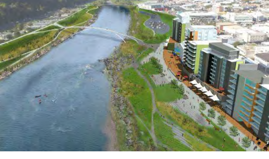
AUGUST 2019
PAGE I 31
An impression of what the Hutt River riverbank could look like once flood protection works are completed.
Ruamahanga River (Greater Wellington Regional Council)
The Ruamahanga River Scheme (Lower Wairarapa Valley Development Scheme) was developed by
central government from the mid-1950s through to the mid-1980s with the primary purpose, at the
time, of increasing land use productivity. It has been extremely successful in achieving this outcome,
but the future challenges of climate change, coupled with a desire now for a better environmental
outcome and the need to address Iwi aspirations imply a need for inputs beyond the resources and
affordability of the local community.
Currently there are several initiatives in front of the community including the Ruamāhanga Whaitua
Committee’s desire to further develop kaitiaki roles. Restoring the mauri of the wetland area is a part of
what kaitiaki expect as one of their responsibilities. Restoration projects to restore the balance of nature
on the public land are supported by farmers and the wider community, with the Department of
Conservation, iwi, regional and local councils working together to protect the wetlands for future
recreational enjoyment.
Six wetland waterbodies located in Wairarapa Moana have been selected to be restored and monitored
as part of the ‘Fresh Start for Freshwater’ Program. Fish are one of the variables to be monitored as
indicators of restoration success.
Local and regional ratepayers are currently contributing considerable sums of money and are looking
for a contribution from central government to recognise the national benefits of this work.
The primary reason for active central government co-investment in the Wairarapa Moana area is
therefore that it:
• Contributes to the environmental and water quality expectations of communities and iwi
partners.
• Is supportive of job creation and lifting the productive potential of the regions (the area is a
critical provider of employment opportunities and is a prominent agricultural region).
• Is beyond the ability of the adjacent land owners to fund.
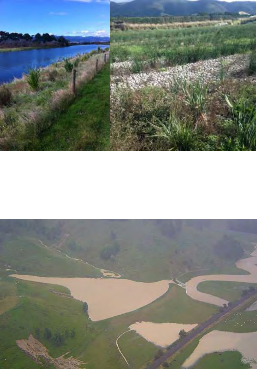
CENTRAL GOVERNMENT CO-INVESTMENT IN RIVER MANAGEMENT FOR FLOOD PROTECTION
PAGE I 32
Extensive ‘environmental enhancement’ planting as part of the Lower Wairarapa Valley Development Scheme.
Matarawa, Porewa and Tutaenui Flood Control Schemes
(Horizons Regional Council)
This scheme comprises a series of flood detention dams built with substantial central government
funding, in the 1950’s and 1960’s to provide protection to the state highway network in the Hunterville
area.
Photo: State Highway and North Island main trunk railway line near Hunterville protected by Porewa Dam
during 2004 flood event.
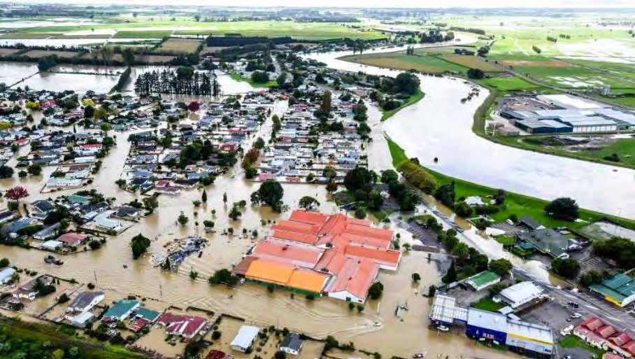
AUGUST 2019
PAGE I 33
The flood storage dams were designed for a 25-year return period, and the spillways were designed for
a 100-year flood, based on the design models of the 1950’s and 1960’s. The Porewa Scheme consists of
27 dams.
Subsidy funding from central government for maintenance (1:1) ceased in the late 1980’s. The
replacement cost of the Scheme is estimated at $9.7m. Review work is underway, including recognition
that the funding model needs revisiting.
The primary reasons for active central government co-investment in the scheme are it:
• Directly protects government assets (State highway one and the main trunk rail line) and
therefore, provides effective transport functioning and connectivity throughout the southern
part of the North Island).
Rangitāiki River Scheme (Bay of Plenty Regional Council)
The April 2017 flood event caused major damage and personal trauma and it was fortunate, some would
say sheer luck, there was no loss of life. Increasing community resilience and managing flood risk in the
Rangitāiki catchment, in conjunction with implementing the recommendations from the ‘Rangitāiki River
Scheme Review’, is a priority for the Bay of Plenty Regional Council (BOPRC).
Extensive inundation of Edgecumbe following the failure of Rangitāiki River stop-banks in April 2017.
BOPRC have already invested in the replacement of the College Rd stop-bank and wider catchment
urgent flood repairs as a result of the April 2017 Flood Event. Attention has now turned to the long-term
and catchment wide approaches that respond to climate change and provide wider cultural and
ecological benefits.
The BOPRC River Scheme Sustainability project is investigating and implementing this whole of
catchment response. The priority now is the lower Rangitāiki: increasing the capacity of the Floodway,
securing the river Spillway, geotechnical strengthening, and improving the wider catchment flood
defences in the face of climate change and a vulnerable community. Funding is sought to assist with a
package of projects, which will provide ‘1 in 100 year’ protection for the community and local economy.
Increasing the flood capacity to 804 cumecs is needed, in conjunction with system innovations that make
room for the river, use flood plain attenuation, and use multi-functional infrastructure.
CENTRAL GOVERNMENT CO-INVESTMENT IN RIVER MANAGEMENT FOR FLOOD PROTECTION
PAGE I 34
The seven major industries in the catchment have an estimated output of $1.9b per annum and the
project would also provide a high level of protection to Fonterra’s Edgecumbe processing facility. Failure
to act will put these significant sources of regional employment and revenue generation at risk. The
River Scheme also has a high debt levels, accentuated by the 2017 event and scheme rates have risen
26% as a result.
The primary reasons for active central government co-investment in the Rangitāiki River Scheme is that
it:
• Is supportive of wellbeing and social inclusion and reflects equity and ability to pay
considerations.
• Provides for resilience and adaptation against the effects of climate change-induced ‘above
design’ storm events.
• Provides for resilience and increased levels of safety to existing and future communities.
• It will speed up ‘whole of catchment’ innovations and alignment with the Rangitāiki River
Scheme Review. These recommendations may be summarised as follows:
Waipaoa Flood Control Scheme Upgrade - WFCS (Gisborne
District Council)
Upgrade designs for the Waipaoa Scheme will provide protection to Gisborne City and the Poverty Bay
flats against a 1:100-year design flood event. This accounts for climate change factors out to the year
2090.
Current budget costs are estimated at $30-$35m, excluding the cost of the proposed Cycle Trial ($2-
$3m). Most of the Scheme cost is planned for expenditure over a twelve-year period.
The proposed upgrade will widen the stop-bank top width from 2-2.5m to 4m and raise its height 1-2m
with $2m allocated to purchase land under the existing stop-bank and for the proposed widening,
predominantly on the true left bank (Gisborne City side). This will leave approximately 15 per cent of
the stop-bank under private ownership.
Based on a 15-year project duration, annual Capex will be $2.5-3.4m and Opex is $0.5-0.675m. If the
project was shortened to a 10-year project duration, annual Capex would be $3.5-5.5m.
The original WFCS was completed in 1969 following the devastating floods in 1948. The WFCS protects
$7 billion worth of production and horticulture land on both urban and rural areas, effecting the
economic heart of Tairawhiti.
Increasing resilience of the scheme will allow greater certainty for businesses to invest in and on the
land. The scheme allows for socio-economic-environmental growth on Iwi land on Poverty Bay flats.
The scheme has around 75-100 culverts with flood gates. The clear majority of these will need fish
passage provisions retro-fitted if Gisborne District Council’s (GDC) Freshwater Plan and Conservation
legislation is followed to the letter. An Integrated Catchment Management Plan is a requirement of
GDC’s new Freshwater Plan.
GDC’s Land management team are supporting land owners in implementing MPI’s erosion control
funding project in the upper catchments of the Waipaoa River. The scheme protects State Highway 2
and KiwiRail’s rail line. Both assets cross the river. The scheme also protects significant areas of Iwi/Hapu
land.
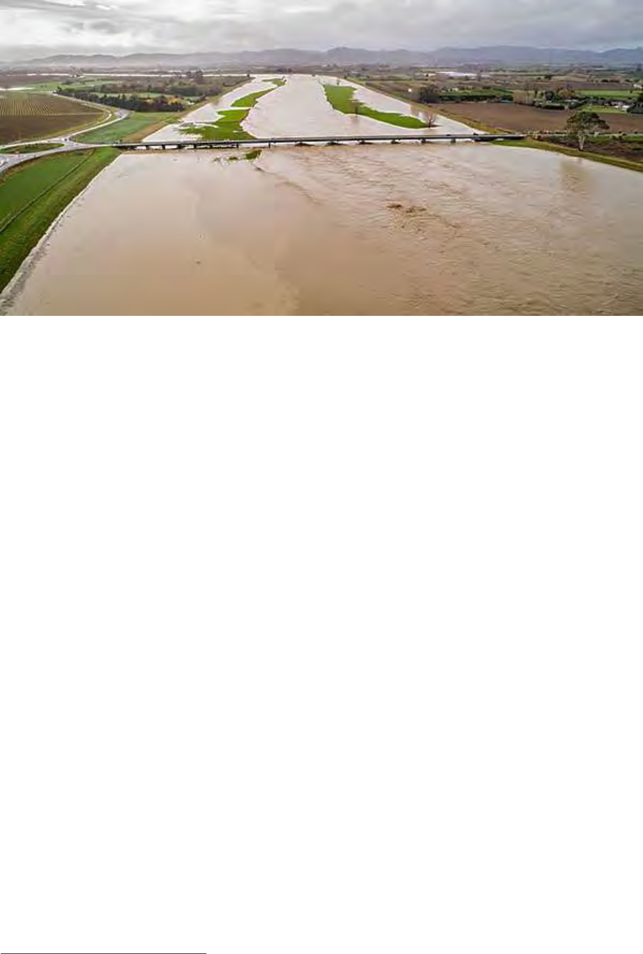
AUGUST 2019
PAGE I 35
Waipaora River stop-banks containing 11 June 2018 flood event at State Highway bridge to Gisborne. NB Te
Karaka township was cut off due to flood waters crossing the State Highway where there are no stop-banks.
The primary reasons for active central government co-investment in the WFCS are therefore that it:
• Is supportive of wellbeing and social inclusion and reflects equity / ability to pay considerations.
• Provides for resilience and adaptation against the effects of climate change-induced ‘above
design’ storm events.
• Provides for resilience and increased levels of safety to existing and future communities.
• Directly protects government assets.
• Is supportive of job creation and lifting the productive potential of the region.
• Contributes to the environmental and water quality expectations of communities and iwi
partners.
Leith Flood Protection Scheme (Otago Regional Council)
Properties in the Dunedin CBD are vulnerable to flooding events. The Leith Flood Protection scheme
plays a large role in protecting the CBD inclusive of education facilities (University of Otago and Otago
Polytech) and the sites for the new Dunedin hospital, public reserves, residential and commercial areas.
The capital value of Crown properties and non-relatable University land and assets, in the area protected
by the scheme, is 35 per cent of the total assets in the area. The dominance of the Education sector in
the Direct Benefit Zone and in the wider Dunedin economy, is a key consideration when evaluating the
costs of flooding.
The benefit received by the University from flood protection is equivalent to the level of economic
impact avoided. This is very significant, not only in direct terms but also in terms of the flow-on effects
of disruption to the wider economy. Six months after this 100 year Annual Return Interval flooding
event, the total economic impact on Dunedin would be $154m. A full year after this flooding event, this
estimated cost was $186m.
36
It is estimated that a flooding event will occur in Dunedin CBD area every 15 years.
The Otago Regional Council (ORC) is implementing the Leith Flood Protection Scheme at an estimated
construction cost of $35m. The scheme is funded by ratepayers. The non-rateable University is a major
36
‘Benefits of the Leith Lindsay Flood Protection Scheme to Crown Properties’, prepared for Otago Regional Council by
Market Economics, April 2011
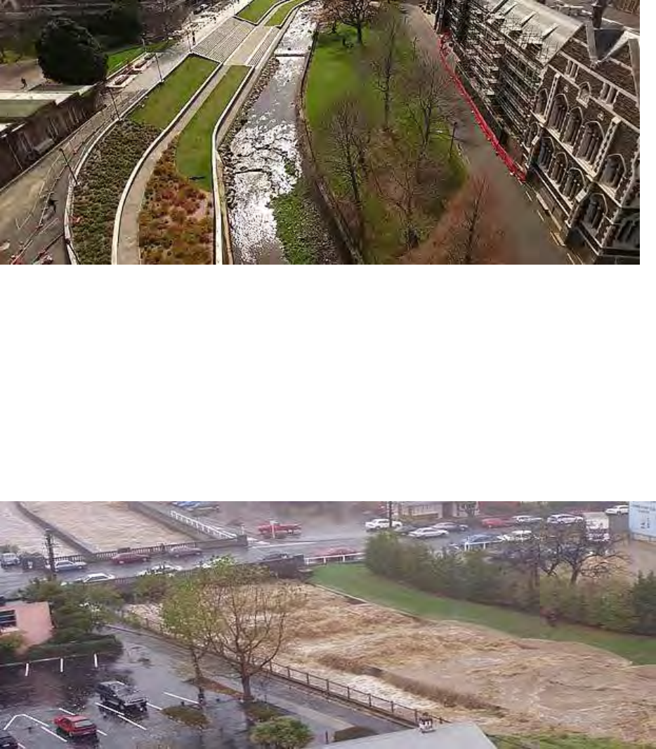
CENTRAL GOVERNMENT CO-INVESTMENT IN RIVER MANAGEMENT FOR FLOOD PROTECTION
PAGE I 36
beneficiary of the existing and proposed flood protection works and yet the University is making no
contribution to flood-scheme costs.
Water of Leith at University of Otago clock tower showing the amenity value achieved through sensitive design
of river control and flood management works.
The primary reasons for active central government co-investment in the Leith Flood Protection Scheme
are therefore that it:
• Provides for resilience and adaptation against the effects of climate change-induced ‘above
design’ storm events.
• Provides for resilience and increased levels of safety to existing and future communities.
• Directly protects government assets.
• Is supportive of job creation and lifting the productive potential of the region.
Water of Leith in April 2006 during a 10 to 20-year Annual Return Interval flood.
Environment Canterbury Scheme Reviews (ECan)
ECan is in the process of reviewing its Schemes to address climate change and other challenges.
ECan have $150k/year general rate funding to spend on scheme reviews. These reviews are assessing
the “fit for purpose” status of existing schemes and the need for / nature of necessary changes. Currently
ECan is in year 2 of this 10+ year programme.
The conclusions so far drawn by ECan from its review highlight two issues:
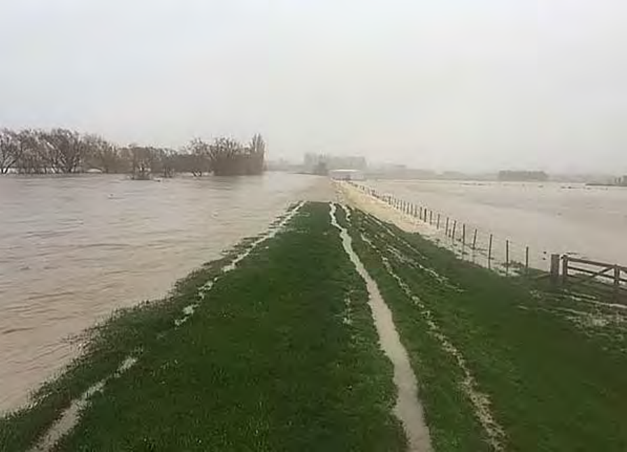
AUGUST 2019
PAGE I 37
• Big Issue 1 – There is demand, because of intensification of development on floodplains, to
develop new and extend existing schemes but that is beyond the ability of existing communities
to fund.
• Big Issue 2 – Climate change impacts will need to be addressed.
Initial estimates, as defined in the ECan 30-year Infrastructure Strategy, suggest the future financial
costs arising from the need to address climate change-induced flood events are as follows (expressed
in 2017 terms):
• Kaikoura Rivers: $3.0m.
• Ashley River: $6.9m.
• Waimakariri-Eyre-Cust: $9.7m.
• Selwyn River: $5.9m.
• Ashburton Rivers: $15.0m.
• Hinds River: $3.7m.
• Orari-Waihi-Temuka: $13.2m.
• Opihi: $10.5m.
• Seadown Drainage: $1.3m.
• Pareora River: $2.5m.
• Waihao-Wainono: $10.6m.
• Other: $2.7m.
• Total: $85.7m.
Photo: Selwyn River stop-bank overtopping in July 2017.
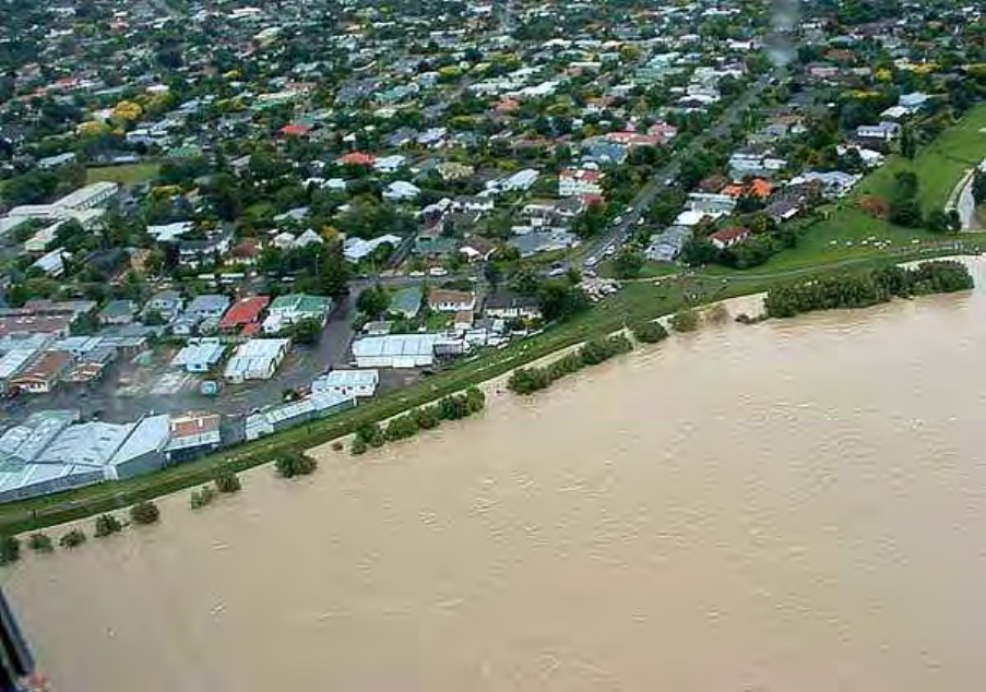
CENTRAL GOVERNMENT CO-INVESTMENT IN RIVER MANAGEMENT FOR FLOOD PROTECTION
PAGE I 38
Appendix 2: from Tonkin + Taylor
report ‘Hiding in Plain Sight’ (April
2018)
An overview of New Zealand schemes
So, what do New Zealand flood protection and land drainage schemes look like? This section provides a
snapshot of river control, flood protection, and land drainage schemes. It covers what’s included and
excluded from a scheme, the extent and quantity of the schemes nationally, and the state of the
infrastructure assets within schemes.
Figure 1.1: Stop-banks protected Palmerston North from inundation during the 2004 Manawatu River flood
event. Source: teara.govt.nz
Schemes – what’s in and what’s out?
The river management activities undertaken by regional councils generally deal with the management
of rainfall runoff on a catchment scale, and are broadly classed into four scheme types based on the
nature of their benefit as follows:
• Land drainage – getting water off the land into a stream or river
• Flood protection – keeping water in the river and off land
• River management – keeping the river where it is
• Tidal inundation – keeping sea water off land.
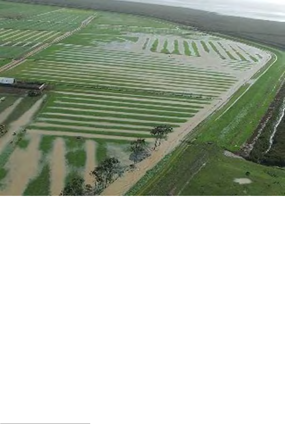
AUGUST 2019
PAGE I 39
Figure 1.2: Surface flooding on productive land served by land drainage scheme, Waikato 2008. Source:
Waikato Regional Council.
Each regional council classifies schemes and their infrastructure assets into these four broad types. This
publicly available information has been used in this assessment.
What is not covered under these schemes and is excluded from this assessment is the management of
storm-water runoff in urban or semi-urban settings by city and district councils. The management of
some flood control and coastal protection schemes by city and district councils such and the Avon-
Heathcote River in Christchurch or the Maitai River in Nelson is also excluded
37
.
Additionally, regional councils undertake soil conservation activities to reduce soil erosion and, in some
instances, these are key elements of flood protection schemes. Although these soil conservation
activities are important to water quality and overall catchment health, assessing the state and value of
them is beyond the scope of this assessment.
Scheme extent
The geographic coverage of river control, flood protection and land drainage schemes can be described
as follows: Infrastructure assets – physical structures which protect land from being inundated by
water, for example, stop-banks, flood gates, pump stations, and river training works.
Capital and operational expenditure associated with these assets are generally funded by rates from the
following areas:
• Direct benefit areas – areas of land which are immediately protected from flooding by
infrastructure assets and would otherwise be subject to flooding during storm events up to and
including the size of a design event
37
The scope of this survey included regional councils and the regional council functions of unitary authorities.
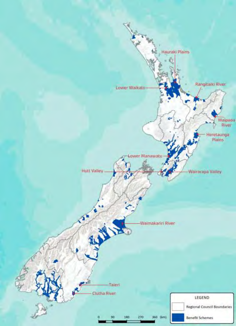
CENTRAL GOVERNMENT CO-INVESTMENT IN RIVER MANAGEMENT FOR FLOOD PROTECTION
PAGE I 40
• Indirect benefit areas – areas of land which sit outside the direct benefit area and receive a
‘community good’ from protection afforded by the infrastructure assets
• Exacerbator areas – upper areas of land in a catchment that contribute runoff to low-lying
portions of a catchment and contribute to drainage or flooding issues experienced in these
lower lying areas.
The direct benefit areas for all scheme types across New Zealand is shown in Figure 1.3, below.
Figure 1.3: Extent of direct benefit areas
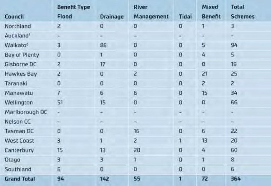
AUGUST 2019
PAGE I 41
Number of schemes
There are around 364 river control, flood protection, and land drainage schemes administered by
regional councils across New Zealand that have been included in this assessment.
A breakdown of the number of scheme types by region is given in Table 1.1 below. We found that how
the nature of scheme benefit is described varies depending on the scheme. Specifically, some schemes
provide a single benefit type only, while other schemes provide multiple benefits. For those schemes
that provide multiple benefit types, the available data was insufficient to understand the proportion of
benefit type.
For example, there are a large number of schemes in the Waikato that are identified as only providing
drainage benefit. This is contrasted with the Kaituna scheme in the Bay of Plenty that provides flood
protection for an event having a 1% Annual Exceedance Probability (AEP) and drainage protection for
events up to 20% AEP.
Schemes with multiple benefit types were most common for regional councils in the Bay of Plenty,
Hawkes Bay, Manawatu, and West Coast. Future data analysis would be made easier if the schemes or
their constituent parts were able to be classed under a single benefit, though we recognise this may be
difficult.
Table 1.1: Number of scheme types by region
Notes:
1. Council reported it does not have any relevant schemes under management.
2. No data was provided for schemes protecting urban settlements in Taupo and Thames – Coromandel Districts.
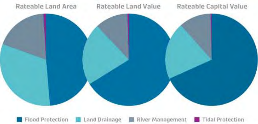
CENTRAL GOVERNMENT CO-INVESTMENT IN RIVER MANAGEMENT FOR FLOOD PROTECTION
PAGE I 42
What schemes protect
The 364 schemes for which data is available provide direct benefit to some 1.5 million hectares of land
(about 5.6% of New Zealand’s land area). As noted previously, schemes provide benefit beyond the areas
of direct benefit. Regional councils recognise this through the identification of indirect benefit areas and
exacerbator areas for the purposes of striking a rate to fund the schemes.
In addition to the rateable areas of benefit that schemes protect — or otherwise provide a ‘community
good’ — schemes also protect non-rateable land and regionally and nationally significant infrastructure,
including transportation, energy and telecommunication links. For example, State Highway 1, the North
Island Main Trunk Line, and a trunk fibre optic cable are protected by the Lower Waikato scheme. Social
and cultural infrastructure, for example, the Hutt Hospital and numerous schools, marae, libraries and
churches, are protected by the Hutt Valley scheme.
The available scheme rating databases from each region were combined to prepare Figure 1.3, below.
This figure shows the four benefit types relative to each other for rateable land area, rateable land value,
and rateable capital improvements (capital value less land value).
Figure 1.3: Comparison of benefit proportions for rateable area, land value, and improvements value by
scheme type based on available data
Discussion
As illustrated in the pie charts, flood protection schemes protect an increasingly greater proportion of
rateable land area, land value and capital value compared to other scheme types. This indicates that
flood schemes may protect a greater portion of urban land — with capital improvements —than other
scheme types.
Land drainage schemes comprise approximately half of the total number of schemes in this
assessment. However, they protect a disproportionately small amount of rateable land area, and a
diminishing proportion of rateable land value and capital improvements. This is indicative of the more
rural nature (primary industry production) of land protected by these schemes.
The same diminishing proportion of rateable land area, value, and capital improvements are observed
for tidal protection schemes. Again, this is indicative of the rural nature (primary industry production)
of land protected by these schemes. For example, the area protected from tidal inundation in lower
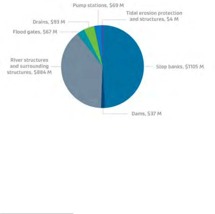
AUGUST 2019
PAGE I 43
Piako River is the largest area of tidal protection benefit, as this scheme covers an extended area of low-
lying farmland near or below sea level.
A diminishing proportion of rateable land area, value, and capital improvements is also observed for
river management structures. However, these structures are often integral to flood protection schemes.
The data does not clearly illustrate a linkage between these structures and the type of land they benefit.
Further work would be required to demonstrate this link at a national or regional level.
Infrastructure assets
Asset value
The total replacement value
38
of river control, flood protection and land drainage infrastructure assets
is approximately $2.3 billion. This is about 4.5% of the estimated $45 billion replacement value of assets
for three waters infrastructure (drinking water, waste water, and storm-water) as stated in Treasury’s
Thirty-Year NZ Infrastructure Plan 2015-45.
The total replacement value of infrastructure assets (about $2.3 billion) is broken out by asset type in
Figure 1.4, below.
Figure 1.4: Summary of total replacement value by asset type for provided data
Flood protection is generally provided by stop-banks and dams. Across the assessed councils, these
assets make up about half of the capital investment but provide almost three quarters of the capital
value protected. In other words, the capital value of land protected by stop-banks and dams is
disproportionally higher than the asset value.
The same pattern can be seen for assets including pump stations, floodgates and drains which provide
land drainage. These assets make up about a tenth of the total capital investment and from this provide
benefit to around a fifth of the capital value protected.
River structures, such as groynes, rockwork and other armouring, training banks, weirs, and
trees/vegetation, are associated with both flood protection and river management as noted above.
38
Total replacement value of the infrastructure assets is based on the valuations published in the asset management
plans available for this assessment.
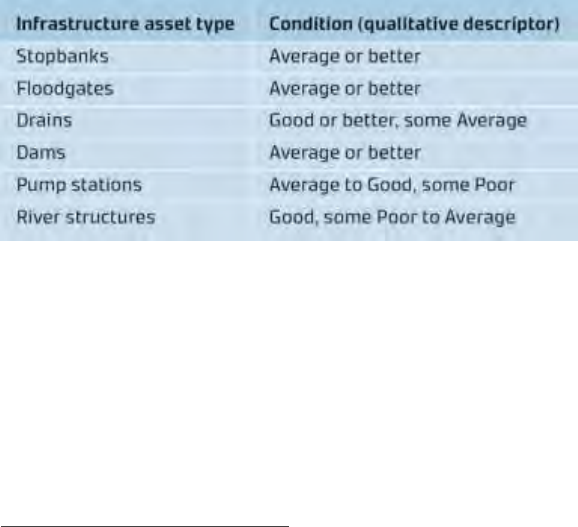
CENTRAL GOVERNMENT CO-INVESTMENT IN RIVER MANAGEMENT FOR FLOOD PROTECTION
PAGE I 44
However, based on the data provided it is difficult to apportion value of these assets to those benefit
types. We note that river structures are often capital intensive and integral to flood protection schemes,
and the river structures themselves may not directly relate to a large area of benefit.
Further work is needed to better understand how river structures integrate with flood protection
schemes, and how the river structure capital and economic values could be apportioned to discrete
benefit types.
Asset condition
A fundamental aspect of asset management is the systematic inspection and recording of asset
condition. The International Infrastructure Management Manual (IIMM) 2015
39
uses a five-point scale
for asset management scoring. For the purposes of this assessment we have used the IIMM qualitative
descriptors (Excellent/Good/Average/Poor/Failed) instead of a one to five scale.
Based on the data available for this assessment, it appears all regional councils use the NAMS scale.
However, there is little, if any, asset condition assessment standardisation across the councils or even
within a council. In our experience, the way asset condition is assessed can vary depending on who
undertakes the assessment and when the assessment is carried out. For example, staff who are very
familiar with an asset can become complacent with its condition and overlook some shortcomings.
Additionally, in absence of condition scoring guidance staff departures can result in new staff using a
different reference point to score asset condition.
The sector has recognised that standardisation in asset condition scoring is important and has recently
developed a stop-bank condition assessment framework that all councils should adopt. Development
of further assessment frameworks for assets such as for pump stations, floodgates and the like, is
beneficial and should be considered by river managers.
The overall condition of river control, flood protection and land drainage infrastructure assets is
summarised in Table 1.2, below. Data is based on conditions published in the asset management plans
made available for this assessment.
Table 1.2: Asset condition summary
At an overview level, the asset condition scores suggest regional councils have adopted an appropriate
level of asset management, renewal and upgrade according to asset type. Scores also reflect councils’
general asset management approach of maintaining stop-banks in perpetuity while river and
mechanical structures are worn and then replaced, hence the latter group having a wider range of
condition.
39
The IIMM 2015 is identified by the New Zealand Asset Management Support Organisation as best practice in asset
management.
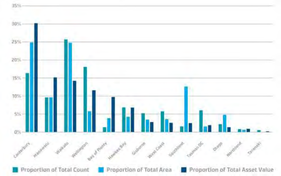
AUGUST 2019
PAGE I 45
The condition of an infrastructure asset does not tell the whole story of how well that asset is being
managed. Asset condition needs to be assessed in conjunction with asset criticality and performance to
understand if and when maintenance or renewal work needs to be carried out. Asset criticality and
performance are generally not well documented by regional councils, and an assessment of these
criteria is beyond the scope of this report. Further work to assess these factors against asset condition
would require a more in-depth scheme by scheme review.
Regional breakdown
A regional breakdown of the number of schemes by type is given in Figure 1.5, below. There is significant
variation between councils in terms of the size and make up of schemes. Figure 1.5 is ordered by total
value of each councils’ scheme assets with two cohorts emerging. One is a cohort of councils —
Canterbury, Manawatu, Waikato, Greater Wellington, Bay of Plenty and Hawkes Bay — covering a
significant overall proportion of asset value. The other, a cohort of councils collectively making up a
smaller proportion of the asset value.
Figure 1.5: Scheme attributes as proportion of assessed total
Economic value of the schemes to New Zealand
A cost benefit analysis was undertaken by economic consultants, Covec, to help define the total
economic value of the schemes included in this assessment.
Covec estimates that the river control, flood protection, and land drainage schemes included in this
assessment provide a Net Present Benefit of $198 billion ($NZD at 2016). Using the sum of the regional
councils’ published infrastructure asset replacement values and operational expenditure of $3.6 billion
($NZD at 2016), the average Benefit Cost Ratio (BCR) of these schemes to New Zealand is approximately
55:1. For comparison, large infrastructure projects in New Zealand, such as those for the NZ Transport
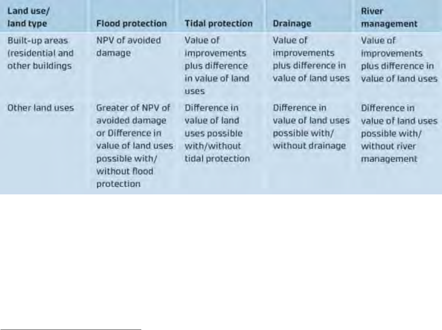
CENTRAL GOVERNMENT CO-INVESTMENT IN RIVER MANAGEMENT FOR FLOOD PROTECTION
PAGE I 46
Agency, are considered economically viable if the BCR is greater than 1:1
40
. As such, with an average
BCR of 55:1, these schemes provide outstanding value for money to New Zealand.
Methodology
A cost benefit analysis (CBA) of the schemes was undertaken by adding all of the estimated benefits of
the schemes and subtracting estimated operational and maintenance costs. To undertake CBA, two
scenarios were assessed:
• The factual case – that is the overall benefit to the community with the schemes in place, and
• A counterfactual case – that is the overall benefit to the community where there are no schemes
in place.
Covec considered three different situations for the counterfactual case and evaluated situations in
terms of the assumptions needed to define them, the analytical problems arising from these
approaches, and whether and to what degree any approach adopted is consistent with best practice for
CBA.
The counterfactual approach that was used for this analysis assumes that to continue to receive the
current scheme benefits, the community is willing to pay an amount equal to value of assets and land
currently protected by the schemes. This assumption, which is further described in Covec’s report, is
made on the basis that the owner of the scheme could otherwise remove these assets.
The approach used to evaluate the benefits to the community was predominantly based on the value
of damage to residential and other buildings, and the valuation of various land use types that are
protected by the schemes. These are described in detail by Covec and summarised in Table 2.3.
Table 2.3: Valuation approach by land use and scheme type (Covec 2017)
For flood protection, the Net Present Value of avoided damage was estimated through the development
of flood risk density curves, whereby the annual average damage for an area of land can be determined
with and without a scheme in place, as shown in Figure 2.6 below. For the purposes of estimating annual
average damages, data from the NZ Insurance Council for floods between 1976 and 2016 was used.
40
Economic evaluation manual, New Zealand Transport Agency, January 2016.
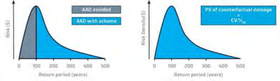
AUGUST 2019
PAGE I 47
Figure 2.6: Annual Average Flood Damage (AAD), and Average Annual Damage avoided with a flood control
scheme in place that has a 100-year return period level of service. The counterfactual is also shown.
Finally, the level of flood damage avoided was modified based on each scheme’s benefit rating, as set
out in their relevant asset management plans.
For differences in land use, Covec used the difference in value of land based on the current use, and
counterfactual use assuming that no scheme was in place.
Covec reviewed potential non-market values such as insurance costs, emergency cost multipliers and
health impacts on the community. Based on work carried out for the Greater Wellington Regional
Council, Covec adopted a value of 100% of direct damage costs to take account of a range of non-market
costs associated with flooding in urban areas. This cost was allocated on a pro rata basis for non-urban
areas based on average population densities for rural areas in NZ.
The data used by Covec for this analysis is outlined in their report. It included:
• The flood level of service for the schemes used in this assessment
• The capital value of land within the scheme’s benefit area
• The land value within the scheme’s benefit area
• The level of benefit provided (low, medium, high)
• Land cover descriptions.
Results
The results are presented across all schemes assessed and separated into scheme types and are
summarised in Table 2.4 below.
Overall the benefits of the schemes are significant with a Net Present Benefit of approximately
$198 billion ($NZD at 2016) at an average Benefit Cost Ratio (BCR) of 55:1. The highest benefits come
from flood control, drainage, and mixed benefit schemes followed by tidal and river control schemes.
The annual benefit of over $11 billion provided by the schemes is nearly five times their published
infrastructure replacement value.
Due to the project steering group’s concerns of the significantly large difference in benefit calculated for
Canterbury region compared with other regions, we reviewed the input data for Canterbury and
Wellington regions and performed a few sensitivity checks. In this review we found some differences in
how these regions supplied their data and rate their schemes.
However, the differences between Canterbury and Wellington appear to be overshadowed by the
relatively large areas of direct benefit, and population within these areas. Using the latest census mesh-
block information Canterbury has about 350,000 normally resident population in direct benefit areas
compared to 75,000 for Wellington’s Hutt Valley.
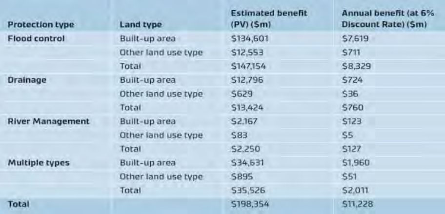
CENTRAL GOVERNMENT CO-INVESTMENT IN RIVER MANAGEMENT FOR FLOOD PROTECTION
PAGE I 48
It should be evident that built-up areas that are protected by these schemes represent the greatest
benefit, which together represent over $184 billion NPV or over $10 billion of annual benefit, compared
with over $14 billion NPV or an annual benefit nearly $1 billion for other land use types protected by
these schemes.
While not all councils are represented in this analysis we consider that the information is sufficient for
an evaluation of the benefits of the schemes to be made at a national level. It is expected that inclusion
of schemes not included in our analysis would return a similar, outstanding BCR. Figure 2.8 depicts the
cost and benefit of the schemes for each region in our assessment.
Figure 2.7 below shows the combined benefit and the benefit cost ratio for each region. This clearly
shows the significant benefit derived from the protection provided in various locations throughout New
Zealand, at various scales, and with different land use types being protected.
Table 2.4: Estimated benefit (2016 $ million) of flood control, drainage, river management, tidal and
multiple schemes
Figure 2.7 shows that the Canterbury region has a very high BCR. This is because virtually all the
Christchurch urban area receives flood protection benefit from the Waimakariri Flood Protection
Scheme. We note that parts of Christchurch are protected by Christchurch City Council’s flood protection
schemes. The costs of these schemes have not been incorporated into our analysis and if incorporated
would reduce the BCR for the Canterbury Region. However, given the small scale of the city’s schemes
relative to the direct benefit area for all the Canterbury schemes, we would expect little change to our
overall findings, i.e. flood protection schemes in Canterbury provide outstanding value for money.
AUGUST 2019
PAGE I 49
Figure 2.7: Benefit, costs and benefit cost ratios for schemes included in this assessment
CENTRAL GOVERNMENT CO-INVESTMENT IN RIVER MANAGEMENT FOR FLOOD PROTECTION
PAGE I 50
Figure 2.8: NPV of scheme benefits and capex + opex costs by region (values indicated where available, subject
to rounding)
Manawatū-Whanganui
AUGUST 2019
PAGE I 51
Exclusions
The economic assessment included in this assessment represents a snapshot of economic benefits and
costs as at 2016. A longitudinal study of how these benefits and costs have changed historically and
might change in the future was excluded from the scope of this review. We would expect that given the
increase in New Zealand GDP and land prices over the past two decades the benefit provided by the
schemes is likely to have increased over this period as a result. However, we are less certain on how
scheme costs and their cost benefit ratios may have changed over that period. Special care would need
to be taken in selecting time periods for such a longitudinal assessment, so the results are not overly
influenced by selection bias.
The economic assessment included in this assessment is traditional in that a factor was applied to the
economic analysis to account for wider social and economic benefits of the schemes. This analysis
excluded a formal assessment of the cultural and environmental costs and benefits given its overview
nature and the complexities associated with assessing these values on such a large scale. We would
expect that the calculated BCR would change if these values were included in a cost benefit analysis. We
would also expect that if these values were included, the schemes overall would still provide a net
benefit to New Zealand given the large economic BCR calculated in this assessment. Further detailed
analyses of individual schemes or portions of schemes may reveal that some are not economic.
Further work would be required to address these exclusions as well as understand infrastructure asset
valuation practices and outcomes and forecast how the benefits and costs of the schemes might change
in the future.
Figure 2.9: Scheme attributes as proportion of national total including economic information

CENTRAL GOVERNMENT CO-INVESTMENT IN RIVER MANAGEMENT FOR FLOOD PROTECTION
PAGE I 52
Appendix 3: Additional information to
support comments made elsewhere
in this paper
What we value
Political manifestos
We can identify the preferences of ministers for supporting initiatives like flood protection and river
management from their political manifestos. The Labour-New Zealand First (2017) coalition agreement
signals some priority outcomes relevant to the government’s role in flood control and river
management. These include:
• Regional Development
o A $1b per annum Regional Development (Provincial Growth) Fund, including:
▪ Other large-scale capital projects as articulated in the policy for the Provincial
Growth Fund, to create jobs, enable long-term sustainable growth, and enhance
social inclusion for all New Zealanders.
o A commitment to relocate government functions into the regions.
• Hold a Public Inquiry “A decade after Shand” to investigate the drivers of local government costs and
its revenue base.
The Labour-Green confidence and supply agreement (2017) also signals priority outcomes relevant to
flood protection and river management. These include:
• Preamble
o Together, we will work to provide Aotearoa New Zealand with a transformational
Government, committed to resolving the greatest long-term challenges for the country:
sustainable economic development including increased exports and decent jobs paying
higher wages, a healthy environment, a fair society and good government. We will reduce
inequality and poverty and improve the well-being of all New Zealanders and the
environment we live in.
Climate change challenges our values
Climate change will make flood consequences much worse
Extreme weather (Local Government New Zealand, 2014) events result in flooding, accelerated erosion
(many landslides are triggered by heavy rain) and wind damage to buildings, infrastructure and crops.
New Zealand currently experiences one major flood every eight months, and this can be expected to
increase with climate change.
AUGUST 2019
PAGE I 53
Climate change (Ministry for the Environment, 2010) is expected to influence flooding in several ways:
through changes in rainfall, temperature, sea level and river channel processes. These changes will
exacerbate the existing effects of flooding on infrastructure, including on:
• Roading.
• Wastewater and storm-water systems and drainage.
• Flood mitigation works.
• Water supply and irrigation.
• Private and public assets, including houses, businesses, schools and production systems.
Extreme consequences from flood events are a global problem
Global research (Environmental Research Web 2018) indicates that both the frequency and magnitude
of extreme flood events has increased, with the total number of extreme floods increasing by an average
of 26.6 per cent over the researched time-period (20 years). The increases were greatest in the northern
hemisphere, with European catchments experiencing a 44.4 per cent increase in extreme floods and
21.4 per cent for the US. The changes have been less dramatic in the southern hemisphere, with an
increase of 14 per cent for Brazil and 11.6 per cent for Australia.
One of the consequences of climate change is a need for a step-
change in management of flood risk and flood flows
Flood risk
Climate change effects on flooding may influence flood risk management priorities and may even
increase the risk from flooding to unacceptable levels in some locations (Ministry for the Environment,
2008).
Climate change is expected to lead to increases in the frequency and intensity of extreme rainfall,
especially in places where mean annual rainfall is also expected to increase. Therefore, changes in
seasonal and annual rainfall patterns, as well as changes in extreme rainfall, will be important factors
for understanding future flooding. Generally, wetter conditions in some areas may also change the
antecedent or initial conditions, so that floods could occur more often.
Places that currently receive snow are likely to see a shift towards precipitation falling as rainfall instead
of snowfall as average temperatures rise and freezing levels climb to higher elevations. Changes in
climate can also affect the magnitude of a flood by indirect means. For example, any change to the
balance of sediment transported within a river, storminess, sea levels or even the cycles of natural
variability in the climate can all influence river processes and flooding.
In addition, climate change will result in a gradual rise in sea level throughout the rest of this century
significantly changing the design conditions for flood control adjacent to the coastal marine area and
requiring both additional capital works and far greater maintenance to achieve the original design
protection. The intensification of land use in floodplains will also require a re-assessment of the design
event given the economic consequences of super-design storms.
With over a hundred cities and towns located on flood plains, New Zealand has a long history of living
with floods. Making decisions on how best to protect life and property from floods has been ongoing
since settlement.
Climate change is already potentially irreversibly affecting our natural systems, and we can expect more
severe effects on the environment and on human systems as the change continues. On land, this could
have a wide range of important effects.
CENTRAL GOVERNMENT CO-INVESTMENT IN RIVER MANAGEMENT FOR FLOOD PROTECTION
PAGE I 54
Rising sea levels and more frequent intense rainfall events are projected to increase the risks of coastal
flooding, erosion, and saltwater intrusion to groundwater, threatening low-lying infrastructure, cultural
sites, and habitats (Parliamentary Commissioner for the Environment, 2015). We can expect tides,
waves, and storm surges to reach further inland more regularly. Coastal flooding, usually due to storm
surges coinciding with very high tides, already causes disruption and damage in some places.
Sea-level rise poses a threat to Māori interests, assets, and values (King et al, 2010; Manning et al, 2015).
Many Māori communities have ancestral ties with coastal areas, and these relationships are maintained
with cultural heritage (e.g. marae, papakāinga and urupā) and mahinga kai (food-gathering sites). These
interests and activities are deeply connected to identity and well-being.
How we currently protect value
In New Zealand, floods present a substantial and recurring risk to the regional economic development
and the productivity potential of the regions. Each flood destroys assets owned by public and private
entities as well as those owned by households.
Government policy is currently focussed on remedy for damage caused after a flood event, rather than
mitigation of flood risk prior to the event. An excessive emphasis on remedy after the flood event and
therefore an implicit acceptance of often irreversible asset destruction is contrary to: lifting productivity
potential in the regions; jobs creation; social inclusion; and healthy societies; and improvement of the
well-being of all New Zealanders and the environment we live in.
This focus has at least the following consequences:
• The Government bears an excessive unfunded future liability in its fiscal accounts to remedy
damage from flood events. Risks of this kind may be viewed as fiscally irresponsible, as has
been pointed out by the Australian Productivity Commission (below).
• Vital infrastructure such as roads, rail, and other public, private and household assets are placed
at unnecessarily high risk of damage leading to disruption to economic output, and social and
environmental well-being.
This disruption affects:
• Industries important for the nation’s economic growth, such as tourism.
• Access routes, such as road and rail, essential for the nation’s commerce.
Any insurance pay-outs for loss cannot fully redress the impact of the disruption. The whole nation
bears continually increasing insurance premiums as successive flood events take their toll, while at a
local level, individuals can find themselves either unable to re-insure or facing extremely high premiums.
The environmental damage to ecosystems from soil erosion and sedimentation of marine environments
from floods, and subsequent loss of productivity of these ecosystems, is not accounted for in fiscal costs
of central and local government but results in lowered production. The environmental damage to
ecosystems from soil erosion and sedimentation of marine environments from floods is also damaging
to the cultural value and amenity of marine environments.

AUGUST 2019
PAGE I 55
Central government as an owner of land, roads and rail is exempt from rates and so does not contribute
to local authority revenue that is applied for flood management infrastructure that would otherwise
mitigate flood risk. This has at least the following consequences:
• There is an unfair burden borne by ratepayers since the central government as a beneficiary of
flood risk mitigation is not contributing to meet its share of this burden.
• There is insufficient funding from regional authorities to meet the flood infrastructure
requirements to protect assets of both ratepayers and central government. This leads to losses
for both, in flood events. If central government did fairly meet its flood risk mitigation burden,
both ratepayers and government would be better off, from reduction in losses from flood
events and ongoing productivity.
Insufficient funding for regional authorities signals:
• Unsustainable local government resources.
• Unfair societies and unsupportive central Government.
Cost of failure of flood protection
Cost to the nation
After earthquakes (Local Government New Zealand, 2014), flooding is second in terms of insurance
payment. It has a combined total (for about 60 flood major events) cost of approximately $865 million
since 1969 (in 2011$).
The costs of hazard events (LGNZ, 2014) are not counted just in terms of the cost of replacing buildings
and other property. Nor even in the number of human fatalities. Very significant costs can result from
the economic and social disruption caused. Sometimes these are tangible (such as the number of hours
or days businesses cannot operate at full production). Sometimes they are intangible, including social
and cultural impacts that have both an immediate and sometimes on-going effects on people’s lives
(including their willingness to want to continue to live in areas subject to hazards). Other costs are
associated with the public cost of responding to events. For example, government expenditure on civil
defence responses during flood emergencies alone averaged about $15 million per year over the period
1976-2004.
The 2004 Manawatu floods provide an illustration of the extent of these types of costs. Insured losses
from that event were $112 million. However, the cost to the agricultural sector alone in uninsured losses
(lost production and uninsurable rehabilitation costs) were calculated at $185 million. The cost of
emergency services and infrastructure repairs was put at a further $90 million. The flood was modelled
as having a 150-year return period.
Cost to sectors
Estimates by Ericksen (1986) cited by the NZIER (2004) shows that for flood losses in Nelson and New
Plymouth in 1970 and 1971, losses associated with central government works and services (roading,
railways, bulk power supply, flood control and drainage works) amounted to 49 per cent of the total
value of all direct losses
41
.
Using Ericksen’s estimates for Nelson and New Plymouth as a guide, and assuming benefits are
proportional to direct losses in this case, the private sector benefits from flood hazard mitigation
41
We note this percent was calculated on the basis of just two storm events.
CENTRAL GOVERNMENT CO-INVESTMENT IN RIVER MANAGEMENT FOR FLOOD PROTECTION
PAGE I 56
amount to 39 per cent of all direct benefits, not including the benefit of averting lost income and
production. Private sector benefits are accounted for by: losses associated with farm land; disaster fund
pay-outs; insurance industry pay-outs; and uninsured property.
The Nelson and New Plymouth studies showed that losses backed by private insurance claims represent
around 19 per cent of direct costs, excluding loss of income and production. This shows the burden of
private insurers is ultimately borne by the nation in terms of higher insurance premiums.
Due to the complex systems and environments where river management is practiced in New Zealand,
the occurrence of a potential shock can have an impact far beyond the immediate community that
receives direct benefit from the scheme. For example, the March 2016 flooding of the Franz Josef
township and closure of State Highway 6. This highlighted that the failure of flood protection in a small
settlement on the West Coast can have a disproportionately large impact on national and economically-
important tourism opportunities and connectivity.
There is a national benefit in simply having a connected and communicating nation. Asset failure
compromises this.
Fig 1 Case study of flood hazard impacts Source: MCDEM Business Plan (2018)
What needs to change
The Australian Productivity Commission view
Internationally there are widespread views that management of natural disasters should place more
emphasis on risk mitigation prior to the event, rather than remedy of loss after the event.
The Australian Productivity Commission (2014 at p 237) made recommendations that help us see the
kind of initiatives that ministers can establish in New Zealand.
The Australian Government should commit to developing a more refined and forward-looking risk-based
formula for the allocation of mitigation funding, in consultation with the states, and within five years. This
should aim to distribute funding on the basis of where the net benefits to the community are likely to be
AUGUST 2019
PAGE I 57
greatest in terms of reducing the economic costs of disasters (including damage to private and public property,
injury and loss of life). The formula should be forward looking and reflect relative levels of future natural
disaster risk across jurisdictions, the community’s vulnerability and exposure to different types of natural
hazards, and the likely effectiveness of mitigation measures. There would also be scope to review the minimum
funding shares for smaller jurisdictions.
The Australian Productivity Commission (2014) noted the following concern for funding for natural
hazard risks: natural disasters can have significant impacts on government budgets and balance sheets.
This means that governments need to understand and manage the financial liability they are exposed
to and put in place measures to finance natural disaster costs.
There are two broad options: drawing on a provision set aside before disasters occur (ex-ante financing),
and, obtaining funds when a disaster occurs (ex-post financing). Both approaches have advantages and
disadvantages, and the optimal approach will likely consist of provisioning for some risks ex ante and
choosing to bear others ex post.
In New Zealand, since local government reform in 1989 and the change in government assistance from
1988 (acknowledging the up to 5-year transition), there has been an excessive emphasis on ex-post
financing. This is likely to be unsustainable in the long-term. A balance of approaches is sustainable. The
Australian Productivity Commission (2014) says that the imbalance at present is fiscally irresponsible:
Natural disasters can have significant impacts on government budgets and balance sheets. This means that
governments need to understand and manage the financial liability they are exposed to and put in place
measures to finance natural disaster costs. There are two broad options: drawing on a provision set aside
before disasters occur (ex-ante financing) and obtaining funds if and when a disaster occurs (ex-post
financing). Both approaches have advantages and disadvantages, and the optimal approach will likely consist
of provisioning for some risks ex ante and choosing to bear others ex post.
The current budget treatment by the Australian and state governments is likely leading to governments
retaining more risk than is optimal. This is because of inadequate understanding of the full range of contingent
liabilities posed by natural disasters, and the overwhelming reliance on ex-post financing for recovery costs.
Such an approach also accentuates the bias against natural disaster mitigation. This is because mitigation is
funded on an ex-ante basis and is included in budget forward estimates, and consequently traded off against
other spending priorities.
Natural disasters are a regular occurrence in Australia. This means that governments need to acknowledge
and disclose the extent and uncertainty of the financial risks that natural disasters pose to their budgets.

CENTRAL GOVERNMENT CO-INVESTMENT IN RIVER MANAGEMENT FOR FLOOD PROTECTION
PAGE I 58
References
Australian Productivity Commission (2014) https://www.pc.gov.au/inquiries/completed/disaster-
funding/report.
Environmental research web (2018)
http://environmentalresearchweb.org/cws/article/news/71020mate
Ericksen, N.J. (1986) “Creating Flood Disasters? New Zealand’s Need for a New Approach to Urban
Flood Hazard”, Water and Soil Directorate, Ministry of Works and Development, Wellington, New
Zealand.
International Panel on Climate Change (2018)
http://www.ipcc.ch/ipccreports/tar/wg2/index.php?idp=171
Labour Green Confidence and Supply (2017)
https://www.greens.org.nz/sites/default/files/NZLP%20%26%20GP%20C%26S%20Agreement%20FINAL
.PDF
Labour New Zealand First (2017)
https://d3n8a8pro7vhmx.cloudfront.net/nzfirst/pages/1911/attachments/original/1508875804/Labour
andNewZealandFirstCoalitionAgreement2017.pdf?1508875804
Local Government New Zealand (2014) Managing natural hazards in New Zealand
http://www.lgnz.co.nz/assets/Publications/Managing-natural-hazards-LGNZ-think-piece.pdf
Ministry for the Environment (2008) https://www.mfe.govt.nz/sites/default/files/meeting-challenges-of-
future-flooding-in-nz.pdf
Ministry for the Environment (2010) http://www.mfe.govt.nz/publications/climate-change-
hazards/preparing-future-flooding-guide-local-government-new-zealand
Ministry for the Environment, “Our Land”, (2018) http://www.mfe.govt.nz/publications/environmental-
reporting/our-land-2018
Parliamentary Commissioner for the Environment (2015)
http://www.pce.parliament.nz/publications/preparing-new-zealand-for-rising-seas-certainty-and-
uncertainty
Provincial Growth Fund (2018) http://www.mbie.govt.nz/info-services/sectors-industries/regions-
cities/regional-economic-development/pdf-image-library/cabinet-paper-feb-2018.pdf
Tonkin and Taylor (2018) “Hiding in plain sight”, prepared for River Managers’ Special Interest Group
Treasury (2018) Investment Statement 2018 p5 – https://treasury.govt.nz/sites/default/files/2018-
03/is18-hphp-wellbeing.pdf
Edgecumbe flooding, April 2017

AUGUST 2019
PAGE I 59
Central Government
Co-investment in
River Management for
Flood Protection
November 2018
